The Far, Far, Eastern Fells
FOUR Wainwright circular walk: Grey Crag, Tarn Crag (Longsleddale), Branstree, Selside Pike
Walk Rating:⭐⭐⭐
Time: 6 - 7 hours
Parking: at Sadgill, at the top of Longsleddale (free)
 |
| Tarn Crag from the old cart track above Sadgill |
 |
| Strava estimates a walking distance of at least 18km |
1. The hike starts at Sadgill, where the tarmac road taking cars up Longsleddale comes to an end. There is room for a few cars to be parked by the side of the arched bridge over the River Sprint - but don't leave it too late to get a place.
 |
| Looking up the valley from Sadgill (Feb 2020) |
2. To start the walk, go through the gate by the stony car parking area into the field behind. Make your way diagonally up and across the field to cross a stile over a stone wall in the top left corner, beyond a small stream.
 |
| Make you way up and across the walled field |
2. You now need to pick out the path that leads up a gully through the crags of Great Howe. At the top of the gully, head right briefly alongside another wall, before crossing over another stile. Head on upwards onto the outcrop of Great Howe. The tall survey pillar on Tarn Crag can be seen over to your left. But our route first heads north, then north-east, to the top of Grey Crag. As you walk on, across the grassy ridge, keep a look out for the Great Howe survey pillar to your right.
 |
| Heading up to Grey Crag |
3. Cross a stile then head right up the slope towards the rocky outcrops above, the summit of Grey Crag. There's a small cairn at the highest point.
 |
| Looking down towards Kendal from Grey Crag |
4. The tall pillar on the horizon, standing at the top of Tarn Crag, makes your next destination easy enough to spot. However, in between the two felltops, lies the marshy area of 'Greycrag Tarn'. To keep your boots at least a little drier, pick your way along the fence line to the right of this boggy depression.
 |
| Skirt around the marshy 'Greycrag Tarn'. |
5. Once safely across, head up the slope to the top of Grey Crag where the tall survey pillar will come into view. A small summit cairn can be found nearby too. The pillar, like the one on Great Howe, was built to help surveyors in the construction of the 'Haweswater Aqueduct' pipeline that runs underneath these fells, taking water south to Manchester.
 |
| The survey pillar on Tarn Crag (Longsleddale) |
6. From Tarn Crag, now head north, following the fence across the grass and peat hags down into the col ahead. To your left, you can see the track from Sadgill heading up and over the Gatescarth Pass. Ahead, lies the grassy mound of Branstree with a stone wall marking the route you are going to take to its top.
 |
| Heading down to the col with Branstree ahead |
7. At the bottom you will be on the grassy col between Longsleddale, to your left, and Mosedale, to your right. A gate marks the route crossing westwards that you will take on your return from the Mosedale Bothy. Head on straight up the grassy slope ahead, alongside the stone wall, all the way to the top of Branstree.
 |
| The circular survey station at the top of Branstree |
8. When you finish the climb at the end of the stone wall, don't expect a spectacular vista to open up ahead of you! Instead, the top of Branstree is a gently curving hill with an odd circular base for use by the Ordnance Survey built into the grassy turf. For the highest point in the hike (at 2339'), this may come as a disappointment but altitude alone does not always guarantee the best views! If you've time, you could walk north, for views down over Haweswater, but a short walk north-east, to Artlecrag Pike, at least provides some interesting columns and another survey pillar nearby.
 |
| The stone columns on Artlecrag Pike |
9. Follow the path along the fence-line to the north-east. The survey pillar can be seen close to a small tarn on your right. To your left, Haweswater comes into view. Ahead lies the final grassy hilltop of Selside Pike, with the Pennines beyond.
 |
| The distant Pennines beyond Selside Pike |
10. The path, and the fence, skirts underneath another rise on the right before climbing to the top of Selside Pike. For such a grassy fell there's a surprisingly large stone shelter on its top.
 |
| The large stone shelter on Selside Pike |
11. Close to the summit, the fence you were following upwards now turns at right angles to the east. Follow the fence down the eastern side of Selside Pike to the top of a 'hanging valley', at the head of Swindale, which lies below you to the left.
 |
| Follow the fence east, down from Selside Pike |
12. At the bottom of the slope, the path crosses over the bed of the small, but fantastically named, Hobgrumble Gill. Head down to the left and you can watch its waters tumble over the crags down into Swindale. The old corpse road from Mardale to Shap heads into this unspoilt valley over the distant ridge to your left.


 |
| Hobgrumble Gill tumbles into Swindale |
13. Once you've finished admiring the view, head back to the fence and head left, carrying on eastwards up the next rise of Nabs Moor.
 |
| Looking back to Selside Pike as you walk further east |
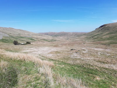
14. Once over the rise, you'll meet the track coming up the valley of the Mosedale Beck from Swindale. If you have time to head down to the left, there are further waterfalls to explore. However, our return route heads right, along the track that runs upstream above the Mosedale Beck. Look out for deer grazing on the isolated hillsides above this broad valley. In about half-an-hour, the white buildings of Mosedale Cottage will come into view, under some protective trees.

 |
| The track to Mosedale Cottage |
15. You can go inside the Cottage, which operates as a freely accessible bothy, including sleeping platforms and even a sofa! However, please treat the bothy with respect and, if you stop for a snack, take all your litter away with you.


 |
| Visit the bothy - but treat it with respect |
16. When you've finished exploring the bothy, head on up the grassy valley to the col between Tarn Crag and Branstree that you crossed earlier in the walk.
 |
| The path heads up to the top of Mosedale |
17. After the moorland feel of Mosedale, the scenery returns to more familiar Lakeland cragginess as you find your way down to the track between Sadgill and the Gatescarth Pass. A signpost marks where your path should come out.
 |
| Back on the road to Gatescarth Pass |
18. Head back down the old road towards Sadgill. There will be waterfalls down to your right and the climbers' rocks of Buckbarrow Crag up to your left, under Tarn Crag.
 |
| Heading back down Longsleddale |
19. Return to where you started the hike, at the bridge over the river at Sadgill.
 |
| Back at Sadgill (hopefully in better weather than this!) |
Worth knowing: Longsleddale appears in documents from the 13th century. It is marked on a 16th century map as 'Sleddale' on the river 'Sput'. Some books link the name of the valley to the 'long sleds' used to haul peat, but it seems more likely to me to derive from the Old English 'slaed', meaning valley. Sadgill in turn probably derives from the Old Norse 'saetr', meaning upland pasture, and 'geil', for ravine.

 |
| Look for this plaque in Kendal |

