SEVEN Wainwright walk: Shipman Knotts, Kentmere Pike, Harter Fell (Mardale) , Mardale Ill Bell, Froswick, Ill Bell, Yoke (and perhaps add Thornthwaite Crag and/or High Street too!)
Walk Rating:⭐⭐⭐⭐
Time: 6 - 7 hours (longer if you want to include High Street)
Parking: at Sadgill, at the top of Longsleddale or on High Lane, Kentmere (free)
 |
| The Horseshoe from Kentmere's High Lane |
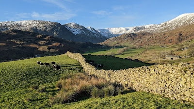
There are some more renowned 'horseshoe' walks in the Lake District, but the Kentmere Round is definitely one that should not be overlooked. It offers relatively easy walking along high ridges, with changing views as you make your way around. It can also be extended to include High Street as well.
For walkers based, like I am, in Kendal, this is our nearest high level walk and one, therefore, that I have enjoyed in various seasons. My preferred route starts at Sadgill, reached by taking the road that runs all the way to the top of Longsleddale from the A6 Shap Road. You could, of course, park at the top of Kentmere itself, but parking opportunities there are more limited.
 |
| Strava estimates a walking distance of at least 22km |
1. Arriving at Sadgill, cross the bridge and head left to find the old cart road passing behind the farm buildings, signposted to Stile End and Kentmere.
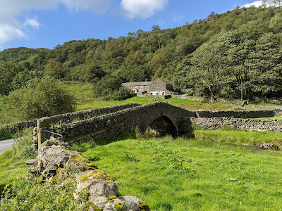 |
| Cross the bridge and walk up the track behind the farm |
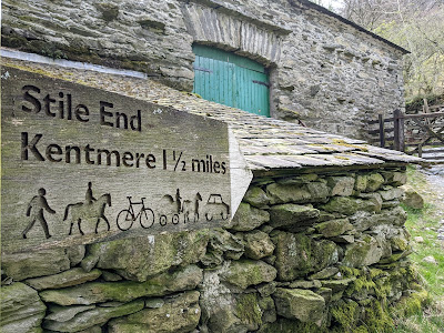 |
| Whatever the sign says, don't try this track with a car! |
2. Walk up the gated road around the hillside, up some steep bends that would be hard going for any carthorse, and then continue on as the wide track levels out as it crosses the top of the ridge in the direction of Kentmere.
 |
| Follow the wide track up to the top of the ridge |
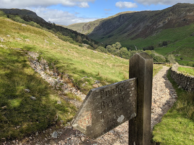
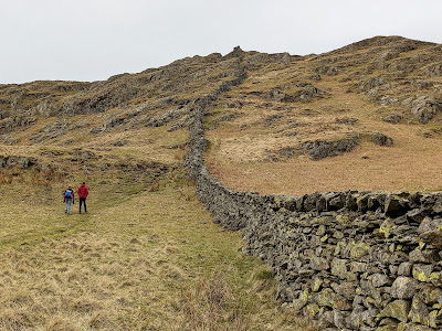
3. Look for a stone wall coming down to the road from the fell on your left. Where the wall reaches the track, a wooden gate crosses the road. Go through the gate and then leave the track to your right, crossing the stream below it.
 |
| Go through the gate and then up the path to the right |
4. Take the path going up the slope, which soon ascends alongside a stone wall. The path climbs over rocky outcrops, quite steeply in places, on the way up to the top of Shipman Knotts. It's a little over a mile to the summit, with some boggy sections to cross in between the outcrops too.
 |
| Following the path alongside the stone wall |
 |
| The last section of the walk up to Shipman Knotts |
5. There's a small cairn to mark the summit (1926') but there's no particular reason to stop for long on Shipman Knotts itself. Continue along the ridge towards the stone wall cutting across the fellside underneath Kentmere Pike, the large grassy fell on the horizon.
 |
| Walk on from Shipman Knotts towards Goat Scar |
6. However, before continuing to Kentmere Pike, it's definitely worth taking a slight detour to the lower rise to the right, Goat Scar. This is a crag to the north of Shipman Knotts that looks out over Longsleddale.
 |
| Goat Scar on the left, looking up from Sadgill |
7. To reach Goat Scar, when you reach the stone wall ahead, use the ladder stile to cross it, then, rather than heading left up the main path to Kentmere Pike, go straight ahead on a thinner path running alongside the wire fence.
 |
| Cross the wall that heads across the hillside |
8. Follow this thinner path until the fence turns at right-angles to head left up the ridge of the fell. You will see a small wooden stile in the fence. Cross the fence and walk out to Goat Scar, the rise ahead with a small cairn on its top.
 |
| Cross the fence and walk out to Goat Scar |
9. You should be rewarded with good views along Longsleddale, both to the north and to the south.
 |
| Looking along Longsleddale from Goat Scar |
10. Return to the wire fence and turn right to follow the fence up the grassy rise of Kentmere Pike, soon re-joining the main path coming up from the ladder stile.
 |
| Cross back over the fence, then follow it up the fellside |
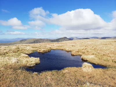
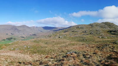
11. Near the top of the rise, the fence becomes a wall again, and there will be a few small tarns and pools to find your way around before you reach the top of Kentmere Pike.
 |
| Reflections in the pools on the way to/from Kentmere Pike |
12. The wall continues right across the top of Kentmere Pike, hiding a triangulation column on its eastern side. There is a small summit cairn to its west (2397') .
 |
Looking west from the top of Kentmere Pike
|
 |
| Looking back along the wall from the triangulation column |
13. The path now continues for a mile or so around the horseshoe, across the peaty ridge, before rising up to the higher ground that forms the top of Harter Fell. At an angle in the wire fence to your right, one path veers off left, across the grass around the side of Harter Fell, a route that gives the clearest views down to the Kentmere Reservoir below. This path comes out above the Nan Bield Pass.
 |
The Kentmere Reservoir under Ill Bell
|
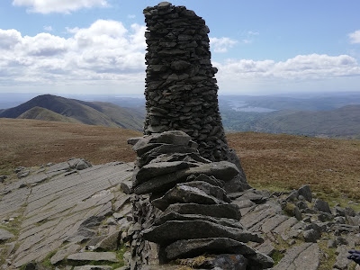
14. Keeping to the higher path, which follows the fence as it heads along the top of the ridge, leads to the summit cairn of Harter Fell (2552'). It is made of both stones and rusted iron posts.
 |
The summit cairn of Harter Fell (2022)
|
 |
The summit cairn of Harter Fell (2020)
|
15. From the summit, follow a cairned path that leaves the top of Harter Fell westwards, descending a ridge that leads down to the col of the Nan Bield Pass.
 |
A panorama showing the route ahead to Mardale Ill Bell
|
 |
A cold morning above the Nan Bield Pass
|
16. There are particularly striking views to your right, down over the tarn of Small Water and out to curving Haweswater.
 |
| Looking out towards Haweswater |
17. The Nan Bield Pass stands on a crossroads of routes. A path descends to the right down to Mardale Head, at the top of Haweswater.
 |
| The Nan Bield Pass |
18. The path to your left heads down into the Kentmere valley, providing an easy return route for walkers looking for a shorter hike (or if the weather has turned against you).
 |
| The view below, if you return to Kentmere from the pass |
19. To continue around the horseshoe, cross the pass, and continue on the paved path that heads upwards again on the other side, crossing above the long ridge of Lingmell End that protrudes into the Kentmere valley to the south-west.
 |
| Looking back along the paved path towards Harter Fell |
20. Continuing upwards across the peaty fellside brings you to the rocky knoll that marks the top of Mardale Ill Bell (2496').
 |
| The summit cairn on Mardale Ill Bell |
21. Make sure to go a couple of hundred yards beyond the summit cairn to find the view out over Blea Water, towards High Street and Kidsty Pike.
 |
| Looking over Blea Water from Mardale Ill Bell |
22. If you have time, you can continue further along a clear path to the summit of High Street. Otherwise, to continue around the Kentmere horseshoe, walk westwards, on one of the thinner paths in the grass that skirt around the top of the valley. There should be good views out towards the ridge of Ill Bell.
 |
| Looking from Mardale Ill Bell across to Ill Bell |
 |
| Heading across the top of the horseshoe |
23. As you skirt across the head of the valley, you should be able to clearly see the beacon column on the summit of Thornthwaite Crag ahead of you.
 |
The beacon on the summit of Thornthwaite Crag
|
24. You can either opt to walk up to the top of Thornthwaite Crag (a Wainwright included in my 'High Street' walk) or skirt beneath it above the steep sides of the top of the Kentmere valley.
 |
| Looking south from the head of a wintry Kentmere |
25. There is now a very clear path to follow along the ridge ahead of you, first climbing up to Froswick (2359'), then down and back up to the conical top of Ill Bell (2484'). |
| The wide path heading up to Froswick |
 |
Looking back towards Froswick
|
26. The top of Ill Bell has three well built cairns, which can be seen on its skyline from a distance. The southernmost one marks the onward route towards Yoke.
 |
| The summit cairns on Ill Bell |
 |
| The southernmost cairn with Windermere beyond it |
27. Continue down and then up to the grassy rise of Yoke (2316'). From the main track, Yoke doesn't hold much interest but, if you still have the time and energy, it's well worth making a detour to look out over the steep crags on its eastern ridge. Where the main track crosses a fence just to the north of Yoke's summit, head east across the grass (best not in the mist!) and you will find impressive views down into the Kentmere valley and back towards High Street.
 |
| Looking back north from Rainsborrow Crag |
 |
| The towering crags of Yoke from below, in the Kentmere valley |
28. From the summit of Yoke, a wide track continues southwards around the horseshoe. Follow it downwards until you reach the track heading up from the valley, across the Garburn Pass. Turn left and walk down to Kentmere village.
 |
| The track down to Kentmere (taken from Sallows) |
29. Once down in the valley, the path passes Badger Rock, used by rock climbers, then heads past the buildings at the outskirts of the village.
 |
| Badger Rock (and the church behind) |
30. You don't need to walk all the way down to the village church, instead take the road that bends up to the left and then becomes an old trackway heading north-east, between stone walls, that leads down to a footbridge over the River Kent.
 |
| Take the road bending up to the left ... |
 |
| ... and continue along the old path between stone walls |
31. Walk up from the footbridge to cross 'Low Lane', then up to the tarmac road of 'High Lane'. Turn left and walk along the road, through a gate, and down to 'Stile End' where the track back towards Longsleddale heads off to the right. This is an alternative place to park a car for the start and finish of the Kentmere Round.
 |
| The start of the track back to Sadgill from Stile End |
32. Walk up the track, through the gate where you started up to Shipman Knotts, then continue back down to Sadgill.
 |
| Nearly back at Sadgill |
Worth knowing: Kentmere gathers the waters of the River Kent into its brief course down to the sea between Arnside and Grange. It is one of the fastest flowing rivers in England. River levels through Kendal can rise very quickly, leading to the serious flooding last seen in 2015, after Storm Desmond.
In the spring, when the bluebells come into flower, the valley of the Kent also offers some of the best spots for seeing them at their best. Beckmickle Ing and nearby Mike's Wood, both near Staveley, are two places that are worth heading to for views.