ONE Wainwright circular walk: Troutbeck Tongue
Walk Rating:⭐⭐⭐
Time: 3 - 4 hours
Parking: roadside by the entrance to the Limefitt Holiday Park (free)
 |
| Troutbeck Tongue from the Garburn Road |
Troutbeck Tongue stands in isolation in the middle of a wide valley, surrounded by the higher ridges of Caudale Moor and Ill Bell. But its moderate height gives it the advantage of being a fell that can be climbed when those higher peaks are hidden in the clouds.
The fell also overlooks an old slate bridge over the Trout Beck, that is definitely worth a visit. If tourists could reach it by car, the bridge would undoubtedly be better known. However, and with the road up the valley closed to traffic, it remains a hidden secret for discerning hikers to find.
 |
| Strava estimates a walking distance of around 10km |
|
1. The hike starts above the Limefitt Holiday Park's 'Haybarn Inn'. So, as with the walk listed over High Street, start by walking into the Park and taking the road over the Trout Beck and up to the Inn at the back of the site. Start the trail on the clear path going left behind the pub.
 |
| Start along this path behind the 'Haybarn Inn' |
2. Ignore the track going south, off to the right, and carry on north along the track. At a rise in the path, the ridge of fells overlooking Troutbeck Tongue will appear ahead of you.
 |
| Looking north on the track from Limefitt |
2. Continue along the obvious track, past a farm and across a ford by an old barn to cross a stream joining from the right. If the weather's been wet, you may need to head up to the hillside a little to find a place to cross over without getting wet boots!
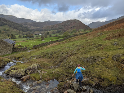 |
| Crossing the stream on the way to Troutbeck Tongue |
3. As you get closer to Troutbeck Tongue, look out for the white buildings of Troutbeck Park at the top of the valley. You will be heading back past this farm.
 |
Troutbeck Park Farm beneath the fell
|
4. The path passes a wooded ravine to your left. Soon after the wood, you reach a gate in a stone wall. Go through the gate then head down left, back through the wall, and down to the small footbridge. Walk up onto a wide track on the other side of the riverbed and head through the gate to your right. Immediately then head up on a faint path through the grass and bracken to the left. The going can be slippery and muddy at first.
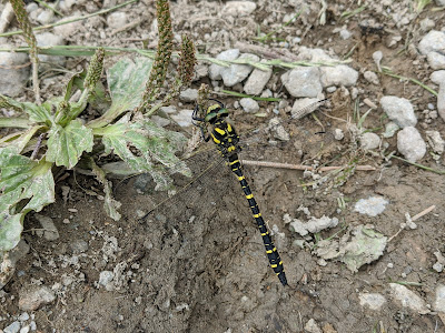 |
| A golden-ringed dragonfly on the muddy path (July 2020) |
5. Follow the path up along the ridge line. You can look west across to the Kirkstone Pass road and north up towards Threshwaite Mouth, the head of the valley.
 |
| Climbing up the steep end of the Tongue towards its summit |
6. The climb levels out as you reach the cairn at its top. The ridge continues to slope away gently to the north, along the longer ridge of this wedge-shaped fell.
 |
| The cairn at the top of Troutbeck Tongue |
7. Now to visit the slate bridge on the far, western, side of the fell. If you prefer walking on known paths, you're best to return to the track, descending the same way as you came up, then take a route around the foot of the fell by Troutbeck Park Farm, before heading up the path above Trout Beck, on the far side of the Tongue. Otherwise, make your own way carefully down the grass on the western side of the the fell, towards a fence.
 |
| Heading down the west side of Troutbeck Tongue |
8. Follow the fence line left, southwards, until you reach a stone wall. Descend, rather muddily if wet, down the side of the wall to where the track from the farm passes through a gate.
 |
| Head down this wall to a gate |
9. From the gate, head right to follow the path that follows the Trout Beck upstream through the woods. You pass waterfalls and rockpools before the path emerges at the slate bridge.
 |
| The Slate Bridge in different seasons |
10. To return to the start of the walk, head back south, above the waterfalls, back to the gate at the end of the stone wall. Go through the gate and down the track to Troutbeck Park Farm. Walk past the farm buildings and continue along the road past a redundant stile in the field to your left.
 |
Signposts, stile, but no remaining fence!
|
11. Walk back along the tarmac road south. It crosses the river on a bridge about half-way to Town Head. Depending on the season, look out for berries, birds and butterflies in the hedgerows.
 |
| A Small Tortoiseshell butterfly in the hedgerows (July 2020) |
12. You can almost avoid walking on the main road by taking an old path to the left that runs between hedges beneath the buildings of Town Head. When this path reaches the main A592 road, you can then walk down the field on your left, parallel to the road. Only when just above the Holiday Park, will you need to go through a small metal gate to walk the last yards of the circuit at the edge of the road.
 |
| Back at the start of the walk |
Worth knowing: Although less publicised than other, more famous, Lakeland properties linked to Beatrix Potter, Troutbeck Park Farm was purchased by the author in 1923. She built up a large flock of Herdwick sheep there and became an active participant in the Herdwick Sheep Breeders' Association.
 |
| Beatrix Potter's more well-known home in Near Sawrey |
In 1943, she was elected its President, but died before her term of office began. Beatrix Potter bequeathed Troutbeck Park, and her other farms, to the National Trust, with her will including a clause insisting that Herdwicks should remain on the farms.
 |
| Herdwicks on the high fells above Troutbeck Tongue |
“There is a kind of sheep in these mountains called Herdwicks - these sheep lye upon the very tops of the mountains in (winter) as well as in summer". James Clarke, A Survey of the Lakes (1787).


