Out to the Nab
FIVE Wainwright circular walk: The Knott, Kidsty Pike, Rest Dodd, The Nab, Brock Crags (plus Rampsgill Head and High Raise if desired).
Walk Rating:⭐⭐⭐⭐
Time: 6 - 7 hours
Parking: at the car park in Hartsop village (Grid Ref: NY410130)
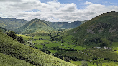 |
| The Nab and Rest Dodd from under Steel Knotts |
The Nab is a 'Wainwright' that is easily visible from Martindale. However, in order to protect the deer in their sanctuary of the Martindale Deer Forest, can only be accessed by a circuitous hike via Rest Dodd from the north.
The walk I have described includes this ridge route out to The Nab but also includes several other nearby fells to make for a full day's walk. It also goes over Rampsgill Head and could easily be extended to High Raise too (both included separately on my 'High Street' route.
 |
| Strava estimates a walking distance of at least 15km |
1. The start of the walk is the same as the route described to ascend Caudale Moor from Hartsop: Go out of the gate at the end of the car park in the village, along the track above the sheep pens. Head on up the valley along the asphalt road to Hayeswater.
 |
| Heading out from Hartsop towards Hayeswater |
2. After a cattle grid, take the right fork and head down to cross the bridge over the Hayeswater Gill. Carry on along the wide track around the northern ridge of Gray Crag.
 |
| Head up the track (pictured from across the valley) |
3. On this walk, stay on the track until you reach a bridge crossing back over the Gill, a couple of hundred metres beneath Haweswater. This is a new bridge constructed after the former dam wall was removed in 2014, returning Hayeswater to being a tarn, instead of a reservoir.
 |
| The bridge crossing Hayeswater Gill |
4. Head up the grass towards the left of the dome of The Knott above, until you meet the wide path coming up from the left over 'Sulphury Gill' (is it my imagination, but doesn't it smell a little sulphurous?) and the Angletarn Pikes.
 |
| Head up the grassy slopes towards The Knott |
5. Continue on the wide path taking hikers onwards to High Street. This path by-passes the top of The Knott so you'll need to leave it and follow the stone wall on its north-western flank to reach the summit cairn.
 |
| Follow up by the wall (Rest Dodd rises behind you) |
6. From the top of the Knott you can look up to High Street and down towards Marthindale.
 |
| On top of The Knott |
7. Now walk eastwards, down and across the High Street path and up to the col above of Rampsgill Head. You will see a path going on across the grass to the further slight rise of Kidsty Pike ahead.
 |
| The rise of Kidsty Pike lies ahead across the grass |
8. From this direction, the distinctive tipped shape of Kidsty Pike, standing up over Riggindale, only becomes clear when you walk around the summit to take in the view across the deep valley over towards High Street.
 |
| Looking from Kidsty Pike to High Street |
9. If you want to also walk a little higher to look around you from another viewpoint, then it's an easy walk across the triangular grassy plateau from Kidsty Pike (2560') over to High Raise (2634').
 |
| From Kidsty Pike over to High Raise ... |
 |
| ... from High Raise over to Kidsty Pike |
10. It's worth heading to the top of the Ramps Gill valley, between High Raise and Rampsgill Head, to look at the profile of the walk ahead, over Rest Dodd and out to The Nab.
 |
| The long ridge from Rest Dodd out to The Nab |
11. Return along the top of the valley, over Rampsgill Head (2598'), for more fine views down into Martindale.
 |
| Looking down to Martindale from Rampsgill Head |
12. Return to the wide path under the Knott, follow it a little to the right, then follow the long wall down and then up to the top of Rest Dodd. This wall follows the same line as the one that you followed up to the top of The Knott, but heading in the opposite direction.
 |
| Walking along the wall up to Rest Dodd |
13. It's a fair haul up to the summit cairn at the top of the grassy mound of Rest Dodd.
 |
| On the top of Rest Dodd with Rampsgill Head behind |
14. From the top of Rest Dodd, you will see the long ridge heading north to The Nab. Walk down the steep fellside and along the peaty ridge. Look out for deer in the valleys on both sides of you - but keep your distance from any herds that you might see.
 |
| The peaty ridge of The Nab |
15. The grassy slopes at the end of The Nab make a good viewpoint down into Martindale. Look out for the red roof of 'the Bungalow' down to the right, just over the Rampsgill Beck. (Find out more by reading 'worth knowing' below)
 |
| Looking north from the end of The Nab |
16. Now return south along the ridge towards Rest Dodd. This time you don't need to climb all the way back up the fell. Instead, find a gap in the sone wall running beneath it and head along the south side of the wall westwards towards the ridge of Satura Crag. Again, keep an eye out for deer below you in Bannerdale.
 |
| Head westwards along the far side of the stone wall ahead |
17. Go over and down the far side of the grassy ridge and head alongside stone walls taking you south-west in the direction of the last small rise of Brock Crags. There are good views to your left and right.
 |
| Gray Crag from across the wall heading to Brock Crags |
 |
| Angle Tarn and Place Fell over to your right 18. Walk past a tiny tarn and across the grass to the cairn at the top of Brock Crags. |
 |
| The last yards up to the top of Brock Crags |
19. Brock Crags is the lowest 'Wainwright' of the day but its position high over Hartsop makes for an excellent viewpoint.
 |
| Looking over Brothers Water towards Fairfield |
 |
| North towards Place Fell and the Angletarn Pikes |
20. The way down from Brock Crags also needs some thought. A direct descent down the grassy slopes towards Hartsop, alongside a crumbling wall, is possible, but the going is very steep. A better choice is to head back to the walls below Satura Crag and take a path that descends along a grooved trail back under the top of Brock Crags. You can then turn left, along the line of an old pipeline, down towards the obvious building that was once the filter house for the reservoir. From there, you can walk along a track back down into Hartsop. If you've time, and the weather is good, a paddle in the Hayeswater Gill to your left will soothe tired feet!
 |
| A paddle in Hayeswater Gill |
Worth knowing: The building in the valley with the bright red roof, clearly seen from the top of The Nab, is known as ‘the Bungalow’. It was built by the Earl of Lonsdale in 1910 for Kaiser Wilhelm, when he visited for a spot of deer shooting. In those days, the lower classes certainly weren't welcome to walk across the fells on the Earl's estate!
Fortunately, rights of way are now protected, as indeed are the red deer. However, the conservation area at the head of Martindale means that access to 'The Nab' may be closed during some of the autumn and winter months. If you want to check, contact the Dalemain Estate Office on 017684 86450. At any time of the year, walkers should keep well away from the deer, particularly during calving time.
 |
| The red roof of 'the Bungalow' from The Nab |

