FOUR Wainwright circular walk: Glenridding Dodd, Sheffield Pike, Catstycam, Birkhouse Moor
Walk Rating:⭐⭐ ⭐⭐
Time: 5 - 6 hours
Parking: at Glenridding (£8 for the whole day) or take public transport.
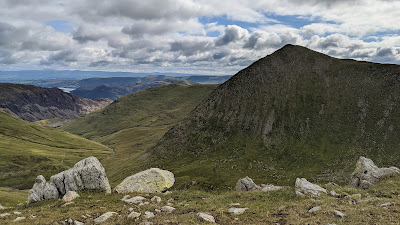 |
| The four fells from above Brown Cove |
Glenridding is thronged in summer, and understandably so, because it provides such a good base from which to explore Eastern Lakeland. The obvious high level walk to do from here is the classic ascent of Helvellyn via Striding Edge, described in another post. However, I have suggested a route which provides a different itinerary, linking together the four 'Wainwrights' that stand to the west of Glenridding, standing apart from the main peaks of the Helvellyn ridge.
The route could easily be divided into two separate walks, walking to or from the Greenside Mine area along the Glenridding valley. However, as one walk it provides striking views of the valley and its surrounding fells from many different angles throughout your day.
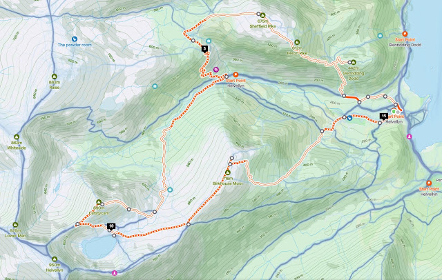 |
| Strava estimates a walking distance of 15km and around 1200m of total ascent |
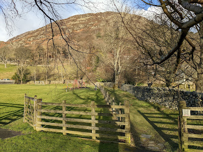
1. From the central car parks, find the public footpath that heads towards Glenridding Dodd, starting out to the right of a children's play area.
 |
| Take the path to the right of the play area |
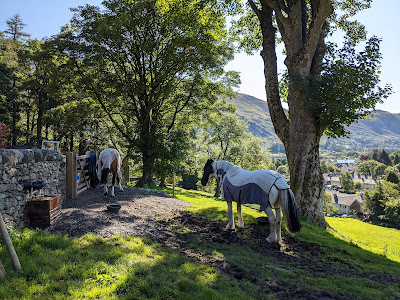
2. Enter the field beyond, where horses are often to be found, and then head up to the left. Leave the field through a metal gate by the wall in its top left corner.
 |
| Horses are often found in the field |
3. Walk past Row Head Cottage and through the gate onto the track above. 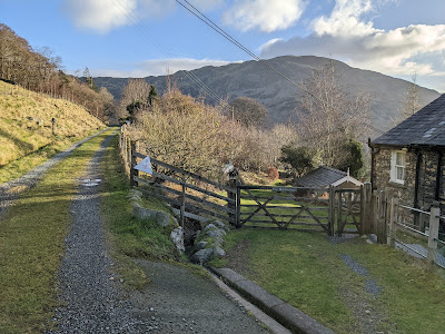 |
Go through the gate, then left onto the track
|
4. Turn left along the track up to the junction with Greenside Road. There is a red post box set into the stone wall opposite. Turn right and walk up the tarmac road, beyond the first set of cottages, until you reach a cattle grid. Cross over, then walk up the path heading up the grassy bank to the right, up to another set of cottages. |
| Turn right up the grass straight after the cattle grid |
5. The path turns back on itself and heads up the fellside. Rather than going straight up the fell, it's best to take the now well worn path that climbs up to the knoll of Blaes Crag, to the right:
 |
| The route to Blaes Crag, then up to the col above |
6. Blaes Crag gives you the first (of many) good views along the Glenridding valley.
 |
| The view from Blaes Crag |
7. Now walk up steeply to the col above, that lies between Glenridding Dodd and Heron Pike, the heathery eastern flank of Sheffield Pike. A stone wall runs across the top of the col.
 |
| The wall across the col beneath Glenridding Dodd |
8. Turn right and walk up to the top of Glenridding Dodd. It's a delightful summit with tress, heather and bilberries and, although only 1450' in height, offers good views out over Ullswater.
 |
Ullswater from Glenridding Dodd
|
 |
| Looking west towards Sheffield Pike and Raise |
9. Now return to the col, go along the left side of the wall and find the path winding up the heathery ridge of Heron Pike.
10. Take your time and enjoy the views. In the summer you will be walking up through purple heather and a carpet of ripe bilberries.
 |
| Looking back to Glenridding Dodd as you climb ... |
 |
| ... and the view to Birkhouse Moor and Catstycam |
11. When you reach the top of Heron Pike, the ground then evens out for a gentler, but less picturesque, walk onwards to the summit of Sheffield Pike itself. You will pass small tarns which, if the sun is shining, stand out against the surrounding grass.
 |
| Walk onwards to the summit of Sheffield Pike |
 |
Look out for the reflections in the small tarns
|
12. The rather plain summit is made more interesting by a stone inscribed with letters and the date 1830, now in two pieces, on its peak cairn. It marked the boundary between the Howard estate of Greystoke and the Marshall estate of Patterdale.
 |
| The inscribed stone on the top of Sheffield Pike |
 |
| The spoil heaps on the col of Nick Head in the distance |
13. Continue westwards, taking care where you put your feet in the boggy ground, towards the spoil heaps of the former lead mine workings at Nick Head, the col ahead of you. From there, head down to the left, cross the Swart Beck, then follow the clear, but sometimes loose, path that zig-zags down into the valley above the site of the former Greenside Mine.
 |
| Head down, above the site of the former Greenside Mine |
14. When you reach the path above the beck below, don't turn right up the valley but instead turn left, back towards the old mine buildings. If you want to leave Catstycam for another day, continuing this way, past the Helvellyn Youth Hostel and along the old Greenside Road, allows a quick return to Glenridding. To continue with the full route, look for the bridge over the Glenridding Beck that lies upstream from the mine workings. Cross over, through the unusually positioned gate on top of the footbridge.
 |
| Cross this bridge and head right, towards Catstycam |
15. Turning left at this point provides another return path to Glenridding. Turning right, and going up the clear path along the valley, continues the walk towards Catstycam.
 |
| Follow the clear path up the valley |
16. The path crosses the Red Tarn Beck and then turns upwards to the left, out of the Glenridding valley.
 |
| Looking back towards Sheffield Pike as the path starts to ascend |
17. The path is well paved, heading up alongside the beck with Catstycam rising up to the right as you ascend. Don't be tempted to try and go across the grass to climb Catstycam too soon. Instead, use the well-trodden path to gain height as it climbs upwards above the Red Tarn Beck and heads around the slope of Catstycam.
 |
| Follow the well paved path below Catstycam |
18. The exact point at which to leave the path isn't clearly marked but look out for a large modern drainage pipe protruding underneath the path to the left. This is roughly where you should then leave the path and start to cross the thick grass towards the peak above you. As you go higher up the slope, the path up the east shoulder of Catstycam becomes much clearer. Follow it upwards.
 |
| Head across the grass. The path becomes clearer on the slope above. |
19. As you ascend, views open up over Red Tarn to your left, and down the valley towards Glenridding and Ullswater to your right.
 |
| Looking out towards Ullswater .. |
 |
| ... and down across Red Tarn |
20. The path reaches the top of the shoulder and then the true summit can be see standing just a little way above it.
 |
| The view up to the summit in the summer |
 |
| The summit shrouded in autumnal cloud |
21. Walk up the final yards to the obvious summit (at 2917', the tenth highest 'Wainwright'), with a cairn at its top and, if the weather has been kind, fine views all around.
 |
| Looking across to the summit of Helvellyn |
 |
Looking across Keppel Cove to Raise, with Skiddaw behind
|
 |
| Looking east towards Ullswater in the summer |
22. Now head down, south-west, along the ridge towards Swirral Edge. There will be a fine panorama ahead of you towards Helvellyn and across Red Tarn.
 |
| Helvellyn and Nethermost Pike, across Red Tarn |
 |
| Looking up Swirral Edge to Helvellyn and its Lower Man |
23. Walk along the ridge until it starts to rise again as Swirral Edge. To your right, you can look across Brown Cove to White Side. To your left, you will see the clear path heading down to Red Tarn, across the lower slopes of Catstycam. Unless you are continuing up to Helvellyn, descend on this path.
 |
| Looking across to White Side, with Grasmoor in the distance |
 |
| A panoramic view over the path down to Red Tarn |
24. As you descend on the wide trail, your onward route, the eastward path across the grass beyond Red Tarn, will be easy to spot. Look out for walkers on the skyline of Striding Edge, to your right.
 |
| The onward path heads east, away from Red Tarn |
25. Take a breather on the shores of the Red Tarn or even, in the summer, a paddle!
 |
Red Tarn in the summer sunshine
|
|
26. Now continue eastwards on the rather dreary path across the grass. It takes you to a ladder stile going over a long wall coming along the ridge from the left. Crossing the stile takes you to a path that descends towards Patterdale. Turning right will take you up to Striding Edge. Instead, turn left and walk along the near side of the wall, north-east towards the rounded top of Birkhouse Moor.
 |
| Head north-east, to the left side of this long wall |
27. As you walk across the top of Birkhouse Moor, walkers are now directed away from the wall to prevent further erosion, and should stay on a higher path. There will be good views back towards Catstycam and Helvellyn to your left.
 |
| Looking back towards Catstycam, in winter and in summer |
28. Shortly before reaching the end of the ridge, and the north top of Birkhouse Moor, the main path bends down to the right, heading to Glenridding. It's worth continuing a short distance onwards to look at the views from the northern cairn.
 |
| On the north top of Birkhouse Moor |
29. Return across the grass to the main path, and follow it back down towards the main wall descending from the ridge above. There will be good views over Ullswater to your left.
 |
| Descending to Glenridding |
30. The path, now paved, turns left away from the wall, and goes down past a crumbling round sheepfold, then through a gate, back down to Glenridding. Just above the village, you will pass a new signpost showing the way you've come, a useful landmark for those walking up in the other direction to tackle Striding Edge.
31. A little distance further down the road, taking a path on the right, heading between the campsite and the beck, will bring you out amongst the welcoming shops and cafes of Glenrdidding.
 |
| Remaining traces of the Greenside Mine |
Worth knowing: The area covered by this walk was once dominated by the Greenside Mine, once the largest lead mine in Cumbria. It was first worked in the 1820s and continued right up until the 1960s, producing over 1 million tons of lead ore (galena) and silver. The mineral vein, according to Ian Tyler*, was worked to a total depth of around 3,000 feet and over a distance of 2 miles. You can read about the mine in more detail here.
 |
| A 1910 plan of the Greenside Mine from Wikipedia |
The landscaping carried out to return the fells to a more natural state mean that the full extent of the mine workings is not that easy to discern to the untrained eye. If you can find a copy, then Ian Tyler's "Lakes and Cumbria's Mines Guide" suggests two different walks around the area, including a walk up to Keppel Cove. Here the remains of failed reservoir dams, used to provide water for the mine, can still be seen. The October 1927 dam collapse, in particular, caused major flood damage to Glenridding.
 |
| *Ian Tyler's book is well worth getting hold of |


