Blencathra and beyond
FIVE Wainwright circular walk: Blencathra, Mungrisdale Common, Bowscale Fell, Bannerdale Crags, Souther Fell
Walk Rating:⭐⭐⭐⭐
Time: 7 hours (if including the walk to Mungrisdale Common)
Parking: free places at the roadside on the A66, just west of Scales (Grid Reference: NY339 267).
 |
| Blencathra from Castlerigg Stone Circle |
Blencathra's shapely outline is a striking sight that can be seen from many other Lakeland fells. There is a wide choice of routes to its summit, from the adventurous ascent along Sharp Edge to the more gentle walk up Scales Fell. I have posted a route which will give you at least a good view of more intrepid souls on top of Sharp Edge, whilst providing a less strenuous, but still very worthwhile, ascent of this magnificent fell. This route should also leave you the time and energy to continue onwards to the four other 'Wainwrights' behind Blencathra.
If your intention is to climb every one of the fells listed by Wainwright in his Guides, then you will want to include the walk out to Mungrisdale Common. However, this grassy expanse is, by general acceptance, including by Wainwright, one of the least interesting of those 214 fells. However, it's definitely worth visiting the other three summits, following a route that also allows you to trace the circuitous route taken by the River Glenderamackin as it flows from the Northern Fells.
 |
| Strava estimates an overall walking distance for the whole route of 20km |
1) Setting out from Scales gives you the advantage of the chance of some roadside parking and also being a little higher in altitude than starting points further west. A short track on the left from the A66, just after the first roadside cottage to the west of Scales, brings you out onto the path running along the bottom of the fellside.
 |
| Looking west from the path at the foot of the fellside. |
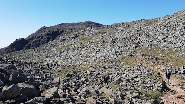
2) The obvious route to take would be to turn right, to choose one of the paths leading to Scales Fell but, instead, turning left makes sure you have a good view of Blencathra before you climb it. You could continue west, to ascend Blencathra via Doddick Fell, but I suggest quickly leaving the main path on the right on a smaller path heading up through the bracken underneath Goat Crags.
 |
| The view of Blencathra as you walk up underneath Goat Crags |
3) The clear path takes you up into the valley of the Scaley Beck where you can look up at the Blencathra summit ridge. However, the path then disappears and, unless you want to try the sketchy direct ascent to the ridge given as one of the many possible ascent routes in Wainwright's Walking Guide to the Northern Fells, it's best to retrace your steps a little, back beneath Goat Crags.
 |
| Looking up the valley of the Scaley Beck to Blencathra |
4) However, rather than losing height all the way back to the main path below, why not just traverse across the grassy slopes above Scales in a north-east direction, gradually gaining further height as you go. Good views open out below you towards Keswick and Clough Head.
 |
| Traversing across the grassy slopes above Scales |
5) Whatever exact route you take across the slope, you will eventually meet the old path, worn into a groove in the fellside in places, that winds up Scales Fell. Following that path (preferable to the more well-used path a bit further east) brings you out on the edge of the escarpment, with the 'saddle' of Blencathra ahead of you.
 |
| Walk up the path onto the summit ridge |
6) Continue an easy walk along the escarpment, looking left down into the valley of the Scaley Beck, the valley that you were looking up at the start of the walk.

 |
| Continue along the ridge above the valley of the Scaley Beck |
7) You could continue on the path you are on up to the top of Doddick Fell, and then to the summit of Blencathra, but, to get a better view of Sharp Edge, take a detour down the slope to your right, towards Scales Tarn.
 |
| Looking across to Sharp Edge, over Scales Tarn |
8) It's worth pausing for a while to look up at the walkers carefully making their way across the top of the narrow edge.
 |
| Walkers on Sharp Edge |
9) Now, bear left to join the alternative path from Scales, that has been climbing up to the tarn below you, and head up the steep slope towards 'Hallsfell Top', the summit of Blencathra.
 |
| Looking down Hall's Fell Ridge, heading to the top of Blencathra |
10) For such a significant summit (at 2847'), there is little to mark it but the views are excellent.
 |
| Looking south-west over the ridge of Gategill Fell |
11) In contrast to the sharp drops to your left, the view to your right will be a gentler slope, heading down to the grassy plateau of Mungrisdale Common.
 |
| Skiddaw and Mungrisdale Common to the north-west |
12) To continue, whether towards Mungrisdale Common, or directly to Bowscale Fell, make your way north in the direction of the grassy "saddle" of Blencathra, but lose height down the slope on your left to skirt below Atkinson Pike/Foule Crag. The head of the valley of the Glenderamackin will be ahead of you.
 |
| The valley of the Glenderamackin lies below you |
13) If you are leaving out Mungrisdale Common, continue down to the col at the top of the valley ahead. Otherwise, continue to lose height to your left, down the slope to the grassy plateau below.
 |
| Heading down to Mungrisdale Common |
14) Follow the path across the Common to what you can just about work out as being its highest point (2077'). There is even a 'summit cairn' to show you where its is! Make sure to tick Mungrisdale Common off your list of "Wainwrights you have walked" (because there isn't really any other reason to be here!)
 |
| The cairn on Mungrisdale Common |
15) It's now a long, and sometimes boggy, trudge along the path that leads across the north of the common to the Glenderamackin col. From there, head left on the path that goes up the (also sometimes boggy) grassy ridge to the summit of Bowscale Fell (2306'). The stony top is marked by a tumbledown wind shelter.
 |
| Blencathra from the top of Bowscale Fell |
 |
| Walking along the escarpment towards Bannerdale Crags |
17) This route gives you the best view of the impressive mile long clifftop that leads to the top of Bannerdale Crags. Walk along the top of the cliffs until you reach the summit cairn of the fell (2241').
 |
| Blencathra from the top of Bannerdale Crags |
 |
| Sharp Edge from the valley of the Glenderamackin |
19) Where the beck bends east at the southern end of the fell, cross the Glenderamackin on the new footbridge (the original bridge was washed away by Storm Desmond in 2015) and walk up to the Mousthwaite col on the other side. (This is the small rise that forces the Glenderamackin to now head north around Souther Fell).
 |
| Crossing the Glenderamackin |
20) From the col, unless you want to now just head back to Scales, a final climb up the grassy ridge ahead takes you up to Souther Fell. The path turns left as it heads northwards along the grassy ridge.
 |
| Looking back at Blencathra and Bannerdale Crags from the ridge of Souther Fell |
21) The ridge undulates over several hummocks until you reach the highest point (at 1713'), when you have walked for about half-an-hour from the footbridge over the Glenderamackin. There is no obvious cairn, just some bedrock sticking out of the grass.
 |
| On the summit of Souther Fell |
22) There is, however, a well-built cairn a little to the south-west of the highest point. So, if you didn't visit it on your way to the summit of Souther Fell, it's worth taking a look from the cairn on your way back south towards Mousthwaite Col.
 |
| The well-built cairn to the south-west of the top of Souther Fell |
23) From Mousthwaite Col, head left down the clear path into Mousthwaite Comb and then return to Scales, either by the path along the foot of the fellside, or along the minor road which handily brings you into the village by the White Horse Inn.
Worth knowing: In one of its pages on Souther Fell, Wainwright's Guide to the Northern Fells draws walkers' attention to the strangely circuitous course taken by the River Glenderamackin on its way towards Derwent Water. It starts by heading south, down the valley that our route takes above, along the western flank of Bannerdale Crags. However, blocked by Mousthwaite col, it then reverses its course to travel back north and then east, around Souther Fell, before being able to take up a southward route once again from Mungrisdale.
 |
| The Glenderamackin veering east under Mousthwaite col |
 |
| The railway trail crossing the River Greta |