NINE Wainwright walk: Barrow, Outerside, Causey Pike, Scar Crags, Sail, Eel Crag, Wandope, Grasmoor, Whiteless Pike.
Walk Rating:⭐⭐⭐⭐
Time: 6 hours (plus time for the return bus journey to Braithwaite/Portinscale)
Parking: some free parking is available for early arrivals (and you need to be!) on the side of the road above Braithwaite leading to the Whinlatter pass.
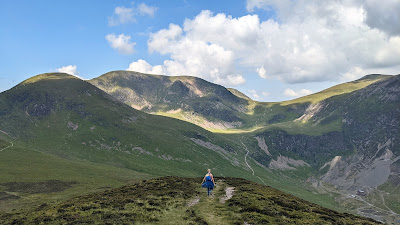 |
| Looking up Coledale from Outerside |
The long, straight valley of Coledale runs through the centre of the North Western fells, ending at the village of Braithwaite, just off the main A66 road to the west of Keswick. It is surrounded by some fine fells that are often walked in a circular 'Coledale Round' route that links summits on both sides of the valley.
However, my route takes advantage of the summer bus timetable to provide a hike that links Braithwaite with Buttermere, taking you not only to many of the Coledale Fells, but also to some fine peaks further west, not least Eel Crag and Grasmoor. It's a route that can provides a walker with a real sense of achievement, linking the summits of nine different 'Wainwrights'. However, it still leaves you plenty of time to enjoy the views, knowing that a bus can bring you safely back to Braithwaite at the end of the day.
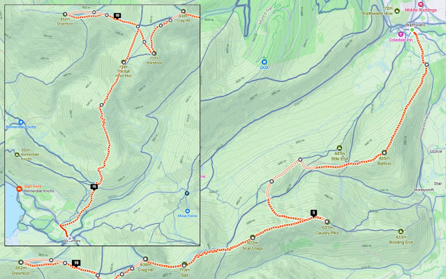 |
| Strava estimates a total walking distance of 16km |
1) It's best to arrive in Braithwaite early, both to find a roadside parking place and to leave plenty of time for your return bus journey. If you need some caffeine, grab a coffee at the village shop, then head up the farm road to Braithwaite Lodge Farm. |
| Walking up to Braithwaite Lodge |
2) A clear path heads through gates behind the farm onto the open fellside. Bear left for a short distance and then turn right to walk up a wide grassy path through the bracken, ascending the ridge of Barrow, the fell rising behind the farm.
 |
| Walk up the ridge to the top of Barrow |
3) From the heathery top of Barrow, you can look behind you back over Braithwaite towards Bassenthwaite Lake, and ahead, to the distinctive summit of Causey Pike.
 |
| Causey Pike, across the valley ahead of you |
 |
| Bassenthwaite Lake, beyond Braithwaite |
4) From the top of Barrow, you can see a conical fell to the west, seemingly out of place compared to its neighbouring high fells, which are all positioned further to the sides of Coledale. This fell is Outerside.
 |
| Follow the path westwards towards the conical Outerside. |
5) Take the clear path that descends westwards from Barrow, skirting around the side of the next little rise of Stile End. The path continues onwards around the southern flank of Outerside as well. However, for a more interesting ascent, leave the main path on the right and walk up a thinner path heading up the eastern slope of the fell. There is a small summit cairn on the rocks at the summit (1863').
 |
| Looking back down towards Barrow from the top of Outerside |
6) Looking up the valley, the remains of the former Force Crag mineral mine, which only finally closed in 1991, can be seen down to the right, underneath Grisedale Pike.
 |
| The site of the former Force Crag mine in the valley below |
7) The fells that our route will now be climbing, rise on the other, southern, side of Coledale. You might be able to make out the zig-zags of the newly engineered path ascending Sail, the domed fell to the south-west.
 |
| Looking west towards Sail, Eel Crag and Coledale Hause |
8) To continue to Causey Pike, take the path that descends steeply down the southern slope of Outerside, back to the main path skirting around the fell, heading south-west towards Sail. But immediately cross over this main path and, instead, find a thinner one slanting up to your left, climbing the grassy fellside towards the distinctive peaked summit of Causey Pike.
 |
| Cross the main path below Outerside and climb the slope to Causey Pike |
9) When you reach the top of the climb, and meet the wide ridge path above, you will find that Causey Pike has several cairned peaks on its bumpy summit ridge.
 |
| Looking west from one of the subsidiary cairned peaks |
10) Walk on eastwards to the last of the cairned humps to reach the official summit (2090'). There are good views in all directions.
 |
| Looking west along the ridge to Scar Crags and beyond |
 |
| Looking north-east towards Skiddaw and Blencathra |
11) Heading back to the west, you should now walk back towards the curving rise of the next 'Wainwright' on the route, Scar Crags. This time, keep to the ridge path along the edge of the steep slope that drops down to the valley of the Rigg Beck to the south.
 |
| Head west along the ridge path towards Scar Crags |
12) As you walk up Scar Crags, the steep southern face is impressive. Sadly, the actual summit (2205'), an elongated grassy ridge, is less so, however.
 |
| Walk along the long summit ridge of Scar Crags |
13) The path drops down slightly to cross the col of Sail Pass then starts the long zig-zag climb up the shoulder of Sail. The new path, built to prevent the soil erosion caused by decades of fellwalkers' feet, makes for a well engineered, but rather dull, ascent. The turf on the top of Sail (2536') provides a good spot to sit and take a breath.
 |
| On top of Sail, with Grisedale Pike in the distance |
 |
| Looking along the valley of the Sail Beck, below Wandope |
14) After a slight depression, the onward route now climbs further, following a narrow crest to the top of Eel Crag.
 |
| The onward path to the top of Eel Crag |
15) On the way along the crest, the path climbs over a couple of rocky rises, offering good views back down over Sail.
 |
| Sail, from the path to Eel Crag |
16) The summit of Eel Crag (a.k.a Crag Hill on Ordnance Survey maps) is an unexpectedly flat area of grass, scattered with stones. There are good views in most directions, although with the foreground obscured by the summit plateau. A triangulation column marks the top of the fell (2749').
 |
| Looking along Coledale from Eel Crag |
17) Rather than heading straight down the western slope towards Grasmoor, it's more interesting to head south-west from the top of Eel Crag to pick up the thin path skirting along the rim of the hanging valley of 'Addacomb Hole'.
 |
| Follow the thin path around the rim of 'Addacomb Hole' |
 |
| Looking back at the steep southern slopes of Eel Crag and Sail |
18) The path leads round to the most protruding part of the grassy felltop, which, together with a small cairn, marks the summit of Wandope (2533').
 |
| On the top of Wandope |
19) If energy, or time, is running short, a descent to Buttermere could now be made. However, it would be a pity to miss out on the summit of Grasmoor, the highest in the North Western Fells. To get there, head north-west across the grass behind Wandope's summit, towards the lower ground between Eel Crag and Grasmoor, at the top of the Rannerdale Beck. From there, the grassy flank of Grasmoor ascends westwards.
 |
| Walk across the grass to the eastern end of the Grasmoor ridge |
20) Now take the clear path heading westwards, up the grassy slope, to climb onto the gently rising pasture at the top of Grasmoor.
 |
| Looking down over Whiteless Pike on the walk up to Grasmoor |
21) The highest point of the fell top (2791'), near its western end, is marked by a stone cairn/wind shelter. There's also another wind shelter a little way below it, on the southern slope.
 |
| Looking down over Rannerdale Knotts |
 |
| Starling Dodd and Mellbreak behind Crummock Water |
22) On your way back along the grassy top towards Wandope, walk over to the northern side of the fell, to see the views from Dove Crags towards Hopegill Head and the Gasgale Crags, beneath Whiteside.
 |
| The Gasgale Crags and Hopegill Head |
 |
| Hopegill Head and Grisedale Pike |
23) At the junction of paths beneath Grasmoor, turn right along the path that crosses the head of the Rannerdale Beck and then descends along the ridge of 'Whiteless Edge'. Crummock Water and Loweswater come into view to your right.
 |
| Crummock Water and Loweswater from the ridge of 'Whiteless Edge' |
24) A slight rise in the descending ridge brings you to the ninth, and final, 'Wainwright' summit of the day, that of Whiteless Pike (2165'). It's an excellent final viewpoint, from where you can look down over Crummock Water, towards the Scafell range to the south, and back along the valley of the Sail Beck towards Causey Pike.
 |
| Looking back along the valley of the Sail Beck |
 |
| Mellbreak, across Crummock Water |
25) An alternative path from Grasmoor, via the ridge of 'Lad Hows', can be seen across the valley to your right.
 |
| The ridge of 'Lad Hows' ascending to Grasmoor |
26) A clear path descends Whiteless Breast, the southern ridge of the fell, zig-zagging in places down to the slight col at the head of the Rannerdale valley.
 |
Looking down into the Rannerdale Valley
|
27) From there, it's only a little way further past the end of the ridge of Rannerdale Knotts, then downhill across the bracken into Buttermere, where various possibilities for well-earned refreshments await!
 |
| Whiteless Pike, looking like an alpine peak, from the valley below |
Worth knowing: The return bus journey towards Keswick can be made in one of two ways. Both routes test the skills of their drivers as they guide their small bus over one or other of two steep mountain passes, but offer their passengers great views.
 |
| Heading up the Honister Pass from Buttermere |
The most spectacular route (the 77, leaving Buttermere in Summer 2022 at 15.18 and 17.18) heads south, over Honister Pass, and then, as a bonus, skirts underneath Catbells too. The downside, however, is that this way back will require you to get off the bus at Portinscale, then walk the remaining mile or so back to Braithwaite.
 |
| Looking back down the road from the top of the Honister Pass |
The alternative route (the 77A, leaving Buttermere in Summer 2022 at 16.24 and 18.24) heads north through Lorton, then up over the Whinlatter Pass, and takes you directly back to Braithwaite. The best views are in the last past of the journey, looking out of the left of the bus towards Skiddaw.
 |
| Skiddaw from the Whinlatter Pass road |


