Haycock & Caw Fell Circuit
FIVE Wainwright circular walk: Middle Fell, Haycock, Caw Fell, Seatallan, Buckbarrow
Walk Rating:⭐⭐⭐⭐
Time: 8 hours
Parking: find a place on the roadside at Greendale, or by Wast Water
 |
| Haycock on the horizon seen from Mickledore |
When you walk below its slopes, it's easy to see from the rounded shape of Haycock how it got its name. However, its outline won't be too familiar to many Lakeland visitors although (as above) it can be spotted easily enough on the skyline looking down from the Scafells. The broad upland of Caw Fell, one of the hardest to reach of the Wainwright Fells, is certainly not well known at all.
This long circuit allows you to visit both fells, together with three others that provide excellent views over Wast Water at the start, and end, of your day.
 |
| Strava estimates a walking distance of around 17km. It is probably nearer 20km. |

 |
| The views from Middle Fell |
2. Continue northwards along the grassy ridge. Greendale Tarn will be down to your left. Head across the col and around the side of Seatallan, the fell rising steeply to your left (you'll be walking up it later in the day!). The rounded dome of Haycock will be in the distance ahead of you.
 |
| Seatallan and Greendale Tarn |
3. The path carries on across the grassland towards the foot of Haycock although it starts to become hard to tell if you are on a human trail or just a sheep track!
 |
| Heading towards Haycock |
 |
 |
| Climbing up the side of Haycock |
5. At the stony summit (2618'), a wall runs along the ridge up towards Scoat Fell. Beyond it, the main cairn takes the form of a large wind shelter with timber for seats. If the sun is shining, it's a scene that's worth the effort of getting there!

 |
| On the summit of Haycock |
6. If you're looking to walk all the Wainwrights, having gone this far you'll now want to add on the extra hour's walk to Caw Fell and back. Follow the wall down the stony slopes to the north-west and you will see the grassy ridge of Caw Fell ahead of you.
 |
| Heading onwards to Caw Fell 7. To save time, skirt around the side of the rise of Little Gowder Crag then stride out westwards back beside the wall to reach a small cairn above 'Silver Cove', on the north side of the wall, which marks the highest top of the uplands of Caw Fell. |
 |
| Great Borne - and Scotland - from Caw Fell |
 |
| Scoat Fell and High Stile from Caw Fell |
 |
| Make your way over to the foot of Seatallan |
9. A path heads steeply straight up the grassy side of Seatallan to reach both a triangulation column and a large stone shelter on its grassy summit. These stones probably originally formed a Bronze Age tumulus.

 |
| Sitting on the top of Seatallan |
10. There's a more gentle slope down the opposite side of Seatallan, heading towards the cairn at 'Cat Bields'. From here, the route goes left, down towards the large cairn at 'Glade How' and then, soon after, reaches the top of the final fell of the day, Buckbarrow. Just as on Middle Fell at the start of the day, there are excellent views to be had, looking down over Wast Water.

 |
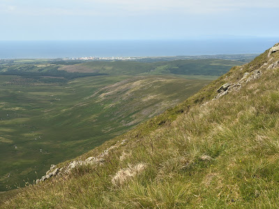
| Looking down over Greendale from Buckbarrow |
11. There's a choice of routes down, one to each side of the crags of Buckbarrow. If you choose to go left, across the crags to the east, you reach the bracken-covered slopes above "Tongues Gills". You will also find the 'Joss Naylor' cairn close by too (see below). A relatively new path makes its slippery way down through the ferns, keeping to this, western, side of the Greendale Gill. You will see the path you started the circuit with on Middle Fell, across the other side of the gill.
 |
| Descending above Tongues Gills |
12. Continue down the path to the sheep folds at the western edge of Greendale, and then back to the road.
 |
| Back at Greendale, under Buckbarrow |
Worth knowing: Champion fell runner and sheep farmer, Joss Naylor, hails from Wasdale and has also left a more permanent legacy on the fellside to the north-east of Buckbarrow.
This tall pile of stones stands, according to Joss, on an ancient cairn. Look for it as you walk above Tongues Gills at the end of the circuit described above.
 |
| Joss Naylor's cairn |

