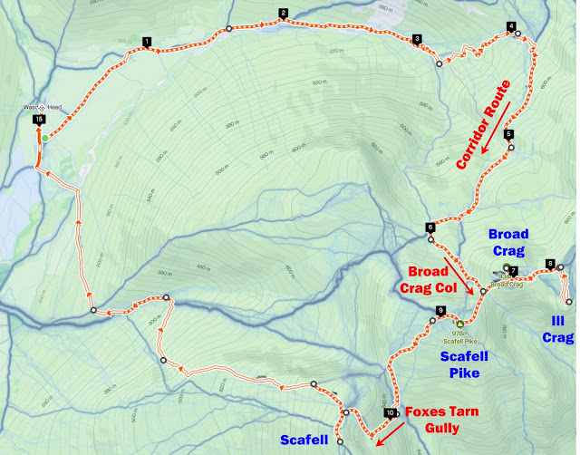
TWO Wainwright circular walk: Scafell Pike and Scafell - plus Ill Crag and Broad Crag too!
Walk Rating:⭐⭐⭐⭐
Time: 6 - 7 hours (15km but about 4500 feet of overall ascent)
Parking: at Wasdale Head Green
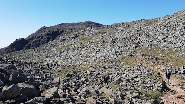 |
| Walking between Ill Crag and Broad Crag (on a day without clouds!) |
Four out of the five highest peaks in England can be reached from Wasdale Head. Scafell Pike (3210 feet) and Scafell (3162 feet) are well known but the other two - Ill Crag (3068 feet) and Broad Crag (3064 feet) - are often bypassed by walkers. In part, their lack of fame is down to Wainwright deciding (and it's a fair decision) that the two Crags are really only subsidiary peaks of Scafell Pike. But geography still places all four peaks above 3000 feet in altitude!
The walk outlined below is for the fit walker who fancies the challenge of reaching the top of all four of these peaks from Wasdale Head in one hike. It ascends via the scenic 'Corridor Route' and then the less often used path up to the Broad Crag col. It also requires descending down to the Foxes Tarn gully in order to be able to ascend back up again to Scafell. The route therefore requires about 4500 feet of ascent - and descent! - overall. But overall, it's a great day out (although sadly one I did on a day that thick clouds settled above 2700 feet or so - so there are no photos of summit views!)
 |
| Strava estimates a walking distance of around 15km |
1. Start out early from Wasdale Head, heading up the usual path along the valley of the Lingmell Beck.
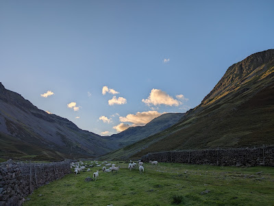 |
| An early start up the valley of the Lingmell Beck |
2. After crossing the narrow wooden bridge over the beck, the 'Moses Trod' route along the flank of Great Gable leaves up to your left. Continue onwards until you reach a fork in the paths. The left-hand fork takes you up to Sty Head. You should take the right fork, keeping to the valley floor.
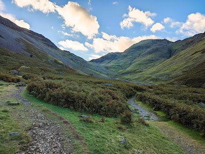 |
| Keep right at this fork, keeping to the valley floor |
3. The path continues through a gate and alongside the beck - and its various pools and waterfalls (as its hard to remember where to look for this route in the Wainwright Guides, it's set out as 'The Valley Route' under 'Great End 7' in the revised Southern Fells Guide).
 |
| Looking up to Lingmell over one of the pools |
4. The path then heads towards the watersmeet between the beck heading down from the chasm of Piers Gill to your right, and the Spouthead Gill coming down from the valley in front of you. Find a place to cross the Spouthead Gill so that you are on its opposite bank.
 |
| Find a suitable place to cross the gill |
5. From here, follow a path that winds up the grassy slopes towards Sty Head at the top of the valley, keeping Spouthead Gill below you, to your left.
 |
| Heading up the valley towards Spout Head |
6. When you near 'Spout Head', at the head of the valley, you can take a shortcut to the Corridor Route, rather than going all the way up to the Sty Head col. To do so, head straight up the slope towards the deep gash in the side of Great End above you, Skew Gill.
 |
| Head straight uphill to the foot of the Skew Gill gully |
7. At the foot of Skew Gill, you will reach the clear path of the 'Corridor Route' heading along the foot of the crags above you. Head right, climbing the muddy slope out of the end of Skew Gill and continue along the Corridor Route.
 |
| The muddy path out of Skew Gill |
8. The Corridor Route is easy to follow and is well waymarked by cairns. There are fine views back down the valley that you have ascended, towards Wasdale Head.
 |
| A young Herdie admiring the views back down the valley |
9. There's really only one tricky section, above Stand Crag, when the path (from this direction) descends over some rocky slabs. Here, you might need to to use your hands as well as feet.
 |
| Looking back at the rocky section - with Great Gable behind |
10. The Route continues on some sections of old paving, heading underneath Broad Crag, towards the top of Piers Gill.
 |
| A clear section of old paving on this section of the route |
11. Before you reach Piers Gill, a paved path leaves the Corridor Route to your left. This is the direct route to the Broad Crag col.
 |
| Take the paved path to the left to head direct to Broad Crag col |
12. I chose to continue on the 'Corridor Route' path a little further, to look down into the impressive chasm of Piers Gill.
 |
| Looking down into Piers Gill from the Corridor Route |
13. From here, the path to the Broad Crag col is not as obvious as the previous one. Head left, away from the 'Corridor Route' path, across the grass towards Broad Crag. You will pick up a path going into the hollow above, which is also met by the direct route (from direction 11 above) coming in from the left.
 |
| Heading into the hollow below Broad Crag Col |
14. Head into the rocky hollow in front of you and make your way up the path that heads up to the scree to the left.
 |
| Take the path up across the scree |
15. The route ascends on the left of the scree slope then heads across the gully to emerge at the top of the col. Here, at a large cairn, you will meet the main ridge route taken by most walkers heading to Scafell Pike from Esk Hause.
 |
| The cairn marking the junction with the main ridge path |
16. Before heading to Scafell Pike, however, there's a diversion to be made to Broad Crag and Ill Crag. Broad Crag can be reached almost immediately by turning left, away from Scafell Pike, along the main ridge path. The main path actually crosses the shoulder of Broad Crag within a hundred metres or so from its summit. So, head left and find your way to what you judge to be the highest point. But tread carefully - the summit is made up of a huge pile of boulders.
 |
| Checking for directions in the clouds on Broad Crag |
17. Descending carefully back to the main path, again head left away from Scafell Pike and up the rise that the main path takes over the shoulder of Ill Crag. Then head right from the path towards its summit. This time there's a little further to walk but across much easier grassy terrain. However, once again, the actual summit is a pile of boulders - with two small cairns competing to be the highest point.
 |
| In the clouds at the summit of Ill Crag |
18. Return the way you came to the main ridge path and head left, back past Broad Crag and the cairn marking your point of ascent from the Corridor Route. This time continue onwards along the well-blazed trail to the summit of Scafell Pike above.
 |
| The last stretch up from Broad Crag col |
 |
| More clouds - on the highest point in England |
19. From Scafell Pike, making sure not to head off in the direction that most tourists take towards Lingmell Col and the Hollow Stones 'highway', instead find the less frequented path that descends to the col of 'Mickledore' between Scafell Pike and Scafell.
 |
| Follow the 'roadsign' on Mickledore towards Eskdale |
20. Between you and Scafell stands the impassable obstacle of the rocky wall of 'Broad Stand'. So, strange that it may seem, to ascend to your last 3000 foot peak, you will first have to descend down the slippery path into Eskdale, to your left.
 |
| The slippery path down towards Eskdale |
21. As you follow the path down from Mickledore, and just beyond the towering crags of Scafell to your right, you will see the long straight gully that you are aiming for. It carries a small stream down from 'Foxes Tarn' - and provides a route back up to Scafell.
 |
| Look out for the Foxes Tarn Gully on the right of the valley |
22. When you get to the foot of the gully, it is possible to ascend at first on a path that climbs to the left of the gully - but you can also climb directly up the gully itself - which has to be more fun!
 |
| Climbing up the gully in the streambed |
 |
| Looking back down the gully that you have ascended |
23. The ways join where the gully widens out and a clear path continues up the streambed to a huge hollow underneath Scafell - in which sits the tiny Foxes Tarn.
 |
| 'Foxes Tarn' underneath the summit of Scafell |
24. From the tarn, the path ascends up the stony slope to your right. At one point, this must have been in a much better condition as occasionally vestiges of a paved path appear as you slog upwards. However, nowadays you will have to mainly just pick the path that seems best until, as you reach the grassier slopes above, an old paved section leads you onto the saddle above at Symonds Knott.
 |
| Looking back down into Foxes Tarn from the stony path |
25. To reach Scafell itself, head left from the saddle up to the cairns that mark its summit.
 |
| The briefest of blue sky above the summit of Scafell |
26. Return towards the saddle above the crags and crevices that buttress the mountain. Head left and downhill along a path which skirts these crags for fine views out towards Scafell Pike, Lingmell and beyond.
 |
| Looking down over Scafell to the mountains beyond |
27. Descending a bit further, you can look down over the final section of 'Lord's Rake' - a classic route up Scafell, although now deemed only 'passable with care'.
 |
| An experienced walker ascending Lord's Rake |
28. From here, it's all downhill across the grass and heather before joining the main tourist paths back towards Wasdale. It's a steep descent but the views over Wast Water are also excellent too.
 |
| Looking out over Wast Water from the August heather |
Worth knowing: This walk takes you to the top of four of the five highest peaks in England - but what are the other peaks in the 'top ten' ?
Not every website will agree - even on the exact heights. 'Subsidiary peaks' like Broad and Ill Crag will be excluded from some lists, but here's mine (all in the Lake District of course - with Cross Fell in the Pennines coming in only at No.11):
1 Scafell Pike - 3,210 feet
2 Scafell - 3,162 feet
3 Helvellyn - 3,118 feet
4 Ill Crag - 3,068 feet
5 Broad Crag - 3,064 feet
6 Skiddaw - 3,053 feet
7 Skiddaw Lower Man - 3,035 feet
8 Great End - 2,984 feet
9 Bowfell - 2,960 feet
10 Great Gable - 2,949 feet


