Haystacks to Red Pike
FOUR Wainwright circular walk: Haystacks, High Crag, High Stile, Red Pike (Buttermere)
Walk Rating:⭐⭐⭐⭐⭐
Time: 7 - 8 hours
Parking: at Gatescarth Farm (daily charge) or along the road to Honister
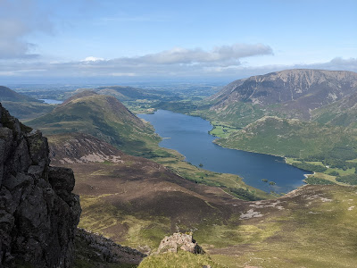
 |
| The three fells on the High Stile ridge from Gatesgarth |
The walk across the three peaks that rise on the ridge to the west of the Buttermere valley - High Crag, High Stile and Red Pike - would be a highlight for any Lakeland walker. However, combining them with one of Wainwright's personal favourites, Haystacks, makes for a long but even more memorable day out on the Western Fells.
The walk as described can easily be split into two - tackling Haystacks separately from the other three peaks - by descending or ascending from the Scarth Gap. Notes on this are also included below.
 |
| Strava estimates a walking distance of around 15km (but it's more like 20km) |

The quarry road with Haystacks beyond
2. The hidden hollow of Warnscale Bottom opens out in front of you. You will be taking a path which zig-zags up through the bracken on the other side of the Warnscale Beck to the quarry road. Leave the quarry road to the right and cross the beck via the wooden bridge.

Cross the bridge in Warnscale Bottom
3. Follow the path upwards. The beck flows down through rock pools and waterfalls to your left. The path first turns to the right underneath Haystacks and then around to the left under the crags. You can see the old quarry road climbing on the other side of the beck, now cut into a ravine.

Waterfalls under Green Crag
4. After about half an hour's ascent from the bridge, Warnscale Bothy appears amongst the rocks to the right of the track. If you're not disturbing any sleeping campers, have a look inside. It is situated spectacularly above the valley below.


The views from Warnscale Bothy
5. Follow the path beyond the Bothy and around and up to the top of the ridge. Turning right, you will join another track coming up from Dubs Quarry and the Honister Pass. A clear path winds its way between small tarns and rocky outcrops towards the summit of Haystacks. (If you are only walking Haystacks, take time to explore the varied corners and tors so loved by Wainwright himself).

Looking south towards Great Gable

A glimpse back down into Buttermere
 |
| Innominate Tarn and the path up to the summit cairn |
6. The highest point of Haystacks (at 1959') is marked by a summit cairn but it is worth taking time to clamber around the various summit outcrops, and the summit tarn, to see varying views of the beautiful scenery around you.


7. To continue the walk now involves close to 500 feet of descent down to the Scarth Gap. The view across Ennerdale to Pillar is magnificent. However, although 'Fix the Fells' are working on the path, it's harder going than some walkers expect!

8. From the pass at Scarth Gap, an improved path winds up and along the ridge called 'Seat' before zig-zagging up the steeper rocky climb of Gamlin End to the top of High Crag itself. (Alternatively, a path descends back down to the top of Buttermere to return to Gatesgarth from the pass. It is also the way up for walkers only hiking the last three peaks).


9. Wainwright describes High Crag as being "the best place for viewing the head of Ennerdale. Backed by Great Gable and overtopped by the Scafells". Sadly, on our walk, the clouds had closed in at this point. Let's hope you have better luck!

10. Finding the onward route along the ridge to High Stile is straightforward, even in cloud, as there is a line of fence posts and a clear path to follow. Nevertheless, there are steep drops down to your right if anyone heads too close to the crags above Birkness Comb!


12. Carrying on round Bleaberry Comb, along the edge of the ridge, the views from the summit cairns and down over Chapel Crags are worth taking time to take in.


13. In under half an hour, the ridge walk will take you to the top (of the Buttermere version) of Red Pike. Once again, there are fine views from the summit shelter.


14. Once you're ready to move on, and remembering that there's still a couple of hours hiking to complete the circuit, head down the well-worn path that descends steeply towards the saddle to the south-east and then on to Bleaberry Tarn. The red soils of the Red Pike are very clear in the very loose section directly beneath the summit, so you need to tread carefully at first. The path improves considerably as it descends to the tarn.

15. At first, the path carries on along Sourmilk Gill as it drains from the tarn but then, because the gill has cut a steep ravine, heads right, to the east. It looks like you might be on a helpful short-cut to the top of the lake but the path then zig-zags down and bends back to the left. It finishes on a path through the trees before coming out at the lakeside at the point where Sourmilk Gill flows into Buttermere.


16. Fortunately for tired legs, the rest of the walk is a gentle stroll on the smooth track around the western edge of the lake.

17. In about half an hour, you'll reach the end of the lake, where the direct path from Gatesgarth heads up to the Scarth Gap. Turn left and cross the fields to the farm, looking up in satisfaction at Haystacks and the path you took up from Warnscale Bottom much earlier in the day.

Views from the top of Haystacks
7. To continue the walk now involves close to 500 feet of descent down to the Scarth Gap. The view across Ennerdale to Pillar is magnificent. However, although 'Fix the Fells' are working on the path, it's harder going than some walkers expect!
'Seat' beyond the Scarth Gap. Pillar rises behind
8. From the pass at Scarth Gap, an improved path winds up and along the ridge called 'Seat' before zig-zagging up the steeper rocky climb of Gamlin End to the top of High Crag itself. (Alternatively, a path descends back down to the top of Buttermere to return to Gatesgarth from the pass. It is also the way up for walkers only hiking the last three peaks).
The path across Seat and then up Gamlin End
The peak of High Crag (but no views on this day!)
10. Finding the onward route along the ridge to High Stile is straightforward, even in cloud, as there is a line of fence posts and a clear path to follow. Nevertheless, there are steep drops down to your right if anyone heads too close to the crags above Birkness Comb!
Looking down across Birkness Comb
11. A mile on from High Crag, the ridge opens out as it meets the spur between the two combs and the top of High Stile is reached. At around 2644', this is the highest point of the walk. There's a choice of cairns and outcrops to choose to look out over the valley below. A small detour northwards along the spur is recommended to take in the view down over Bleaberry Comb (and to note the trail heading down from Red Pike, at the far side of Bleaberry Tarn, which you will be taking to head back down towards Buttermere).
Looking down from the side of the north-east spur
12. Carrying on round Bleaberry Comb, along the edge of the ridge, the views from the summit cairns and down over Chapel Crags are worth taking time to take in.
Looking up to the top of High Stile
Looking down from the top of High Stile
13. In under half an hour, the ridge walk will take you to the top (of the Buttermere version) of Red Pike. Once again, there are fine views from the summit shelter.
At the summit of Red Pike (Buttermere)
14. Once you're ready to move on, and remembering that there's still a couple of hours hiking to complete the circuit, head down the well-worn path that descends steeply towards the saddle to the south-east and then on to Bleaberry Tarn. The red soils of the Red Pike are very clear in the very loose section directly beneath the summit, so you need to tread carefully at first. The path improves considerably as it descends to the tarn.
Looking back up to Chapel Crags from Bleaberry Tarn
15. At first, the path carries on along Sourmilk Gill as it drains from the tarn but then, because the gill has cut a steep ravine, heads right, to the east. It looks like you might be on a helpful short-cut to the top of the lake but the path then zig-zags down and bends back to the left. It finishes on a path through the trees before coming out at the lakeside at the point where Sourmilk Gill flows into Buttermere.
Heading east away from Sourmilk Gill
Then back down towards Buttermere
The cascades at the foot of Sourmilk Gill
16. Fortunately for tired legs, the rest of the walk is a gentle stroll on the smooth track around the western edge of the lake.
Heading back towards Gatesgarth
17. In about half an hour, you'll reach the end of the lake, where the direct path from Gatesgarth heads up to the Scarth Gap. Turn left and cross the fields to the farm, looking up in satisfaction at Haystacks and the path you took up from Warnscale Bottom much earlier in the day.
Looking back towards Haystacks
Worth knowing: I am not sure how well I'd have got on with Alfred Wainwright. One of my Kendal neighbours certainly has little good to say about him! But, whatever he was like in life, there's certainly no doubt that the Wainwright Walking Guides are a fantastic legacy that he left behind for others to enjoy.
After his death in 1991, his ashes were scattered at the edge of Innominate Tarn, under the summit of his beloved Haystacks. If you can find the door open to the small St.James' Church, at the bottom of the road down from Newlands Hause into Buttermere village, you can look up at the fell above the plaque in his memory:
 |
| The plaque inside St.James' Church in Buttermere |

