Loughrigg
ONE Wainwright circular walk: Loughrigg
Walk Rating:⭐⭐⭐⭐
Time: 3 -4 hours
Parking: in Ambleside town centre car parks or on the 'Under Loughrigg' road (free). Even better, use public transport.
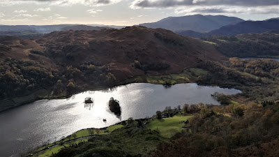 |
| Loughrigg from Nab Scar |
Loughrigg is a little gem. At only 1101 feet in altitude at its summit, only three of the 214 Wainwrights are lower. Yet, if you are looking for a good hike on a day when cloud cover is obscuring the higher fells, Loughrigg Fell is an excellent choice. A series of paths crosses its bracken covered tops, passing small tarns and rocky outcrops, with fine views on all sides.
Wainwright's Walking Guide to the Central Fells describes ascents from six different starting points. As many visitors will be starting from Ambleside, I have chosen a circular route starting from there, giving fine early views back over the town, and, later in the walk, good views down over Grasmere.
 |
| Strava estimates a walking distance of around 10km |
 |
| Miller Bridge |
2. Cross over the bridge from Rothay Park then turn right along the Under Loughrigg road. Cross the cattle grid then turn left and walk up the steep tarmac road going up to some buildings at Browhead.
 |
| Walk up the tarmac road on the left |
 |
| Take the path on the left (trees brought down by Storm Arwen, 2021) |
4. Follow the path briefly through the trees, cross a stream on a wooden bridge and then follow the initially stepped, then muddy, path up the side of the streambed. Bear left and head uphill until you reach a kissing gate in the stone wall above.
 |
| Head through the gate then bear left |
5. To get the best views down over Ambleside, turn left and walk along a path traversing above the line of the wall.
 |
| Looking down to Ambleside |

 |
| Looking down from Todd Crag |
 |
| Head towards Lily Tarn (hidden behind the next knoll) |
 |
| Looking back up to Todd Crag |
 |
| Lily Tarn (2021) |
 |
| Lily Tarn (2016) - then with a tree on the island |
9. Head up from the tarn then down again to a track running alongside the long stone wall. Head left along the wall then, as it bends to the right, cross over a wooden stile.
 |
| Head down to the wall ... |
 |
| ... then cross the wooden stile |
10. Take the path climbing the next rise. The wall that you are leaving behind frames a good view out towards the Fairfield Horseshoe.
 |
| Looking over to the Fairfield Horseshoe |
 |
| Climb up the next rise ahead |
11. Once again, go down the slope to another, wider, track. Where some stepping stones help walkers cross a shallow ford, leave the track as it continues towards Skelwith Bridge, and take the path to the right going up yet another rise.
 |
| Go down to the track ... |
 |
| ... then right on the path after the ford |
12. The path ascends to a slight col on the ridge. Before going on straight, the right route for the top of the fell, it's well worth first taking a small detour along the ridge to the left, towards the top of Ivy Crag. You'll find a good viewpoint for looking down over Loughrigg Tarn, as well as behind you, up to the summit of Loughrigg.
 |
| Looking down over Loughrigg Tarn ... |
 |
| ... and back towards the top of Loughrigg |
13. Returning to the slight col, head left back on the path you took up to the ridge. It takes you to a small trough, going off to your right, containing two small tarns.

 |
| The path passes two small tarns |
14. Once again, head up the rise beyond the tarns. This time, surely, you've made it to the top? I'm afraid not! There is one last descent and ascent required to reach the summit.
 |
| One last climb to the summit! |
15. This last stretch is at least marked by large piles of stones along the route - although, unless visibility is really poor, the muddy path leading along another little valley and then up the steps to the grassy hollow under the summit is not hard to follow.
 |
| The last grassy hollow, from the summit of Loughrigg |
16. Finally, you will have reached the summit knoll, with a triangulation column at its top and good views to be had in all directions.
 |
| Looking down towards Dunmail Raise |
17. A path could be taken from here directly towards Rydal Cave but I suggest you head north-west, in the direction of Dunmail Raise, along the clear path that takes you to a viewpoint giving excellent views down over Grasmere.
 |
| Looking down towards Grasmere |
18. The well-worn stepped descent from here is, I should warn, in need of some work, although it's still easily walked. At the end of 2021, large bags of stones, needed to help 'Fix the Fells' repair the route, were in evidence. It drops down to the smooth pathway of 'Loughrigg Terrace'. Turn right and head along the path, back towards Ambleside.
 |
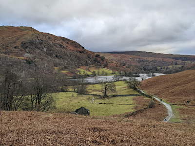
| Loughrigg Terrace in the spring |
19. At a slight brow, the terrace route meets the path heading up from the shore of Grasmere. Going on around the hillside towards Rydal Water, you can take a lower path heading down to the lakeside. However, the higher path is a better choice as it takes you to the entrance to Rydal Cave.
 |
| Looking down to Rydal Water from the higher path |

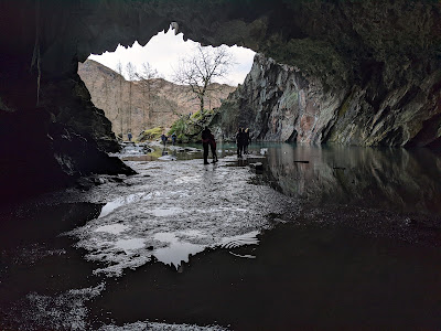 |
| Take a visit into Rydal Cave |
21. After the Rydal Caves, the return to the start of the route is obvious. A path continues around the lake, becoming a tarmac road that takes you to the car parking areas at Pelter Bridge. Don't cross over to the main road, however. Instead bear right, across the cattle grid, and continue on the 'Under Loughrigg' road. It will take you along the River Rothay, until you are back again at Miller Bridge.
 |
| Daffodils by the Rothay |
Worth knowing: As Loughrigg is such a beautiful spot, it will be no surprise that its hillsides were also much visited by William and Dorothy Wordsworth. They often walked along Loughrigg Terrace and also particularly liked Loughrigg Tarn.
In his long philosophical poem, 'The Excursion', Wordsworth writes of the view from the slopes of Loughrigg down over Grasmere as follows:
"We clomb a green hill's side; and thence obtained,
Slowly, a less and less obstructed sight
Of the flat meadows, and indented coast
Of the whole lake—in compass seen! Far off,
And yet conspicuous, stood the old Church-tower,
In majesty presiding o'er the Vale
And all her Dwellings; seemingly preserved
From the intrusion of a restless world
By rocks impassable and mountains huge"

