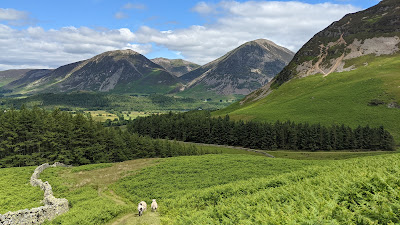
Mellbreak
ONE Wainwright circular walk: Mellbreak
Walk Rating:⭐⭐⭐⭐
Time: 3 hours (less if you leave out the furthest summit)
Parking: Loweswater village (limited free spaces)
 |
| Mellbreak from Whiteless Pike |
As it stands on the other side of Crummock Water, away from most of the tourist traffic, a walk up Mellbreak is easily overlooked. However, this distinctive fell offers an exciting ascent over scree to reach an excellent viewpoint looking out along the length of the Buttermere valley.
Wainwright highly recommends the climb up to the north top of Mellbreak from Loweswater village - a recommendation worth following!
 |
| The signpost by the Kirkstile Inn |
2. Walk along the road in the direction of the "no through road", crossing Park Beck and past Kirkgate Farm. The lane continues between stone walls with the ridge of Mellbreak rising up to your left.
 |
| The lane to the foot of Mellbreak |
3. As you near the woods at a bend in the lane, look out for the ancient earthwork in the field to the right. Looking up, the scree slopes look like they could be challenging - but a path will become clear once you are nearer!
4. Go through the gate and through the trees into open ground beneath the fell. Head up to the left towards the distinctive scree and look for your ascent path. The picture below (taken at the foot of the neighbouring Hen Comb) shows the tracks of the paths you are looking for. The direct route upwards to the right is very steep and loose. The left-hand path is the one to aim for.
 |
| Mellbreak with Grasmoor and Whiteside |
5. The scree is often loose, and the path is worn in places as the route becomes more popular. So, take it carefully as you climb through the heather to what Wainwright describes as the "first promontory". There's a fine view down to Crummock Water, with Grasmoor and Whiteside rising up beyond it.
 |
| Looking back to the village as you climb |
 |
| From near the "first promontory" |
 |
| The views from the "second promontory" |
7. It's only about ten minutes walk further to reach the summit cairn on the north top. From there, the path continues south into a depression between the two summit tops of Mellbreak.
 |
| Loweswater from Mellbreak's North Top |
8. If you want to be sure you've reached the fell's highest point, continue on from the depression to the south top (about half-an-hour's walk from the north top). However, (in 2021 at least!) there was no cairn to mark your achievement, just some rocks appearing out of the grass.
 |
| The rocks marking the 'south top' |
9. The way down is from the depression between the two tops. The broad ridge drops away quite steeply down into boggy Mosedale below. Before you descend too far, there is a choice of paths to look for (marked 'B' and 'C' in the Western Fells Wainwright's Walking Guide). The second photograph below (taken from Hen Comb) shows path 'C' going straight down, while path 'B' (the better choice) traverses across the side of Mellbreak back towards the start of the walk.
 |
| Path 'B' traverses left across the fellside |
10. Path 'B' also crosses some scree, but nothing that presents any difficulty. It comes out on the slopes between the trees and the ascent path at the start of the walk, from which it's an easy stroll back along the lane to the Kirkstile Inn.
Worth knowing: The Kirkstile Inn features in the AA's best Pub Guide with its 'whitewashed walls, low beams, solid polished tables and a well-stoked fire'.


