TWO Wainwright circular walk: Pavey Ark and Thunacar Knott (also visiting other peaks of the Langdale Pikes if desired)
Walk Rating:⭐⭐⭐⭐
Time: 3 - 4 hours
Parking: New Dungeon Ghyll NT car park (£8 for a full day in 2021) or, if you arrive early enough, there are some free roadside places by Rossett Bridge. Alternatively, take the 516 bus from Ambleside.
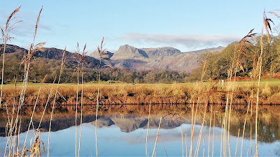 |
| Pavey Ark and the Langdale Pikes over Elter Water |
The cliffs of Pavey Ark look down over Langdale and, directly beneath them, Stickle Tarn. Behind it, much less spectacularly, lies Thunacar Knott, the gently curving fell to which Pavey Ark provides such a sudden eastern boundary. Both are recorded by Wainwright as being different peaks, and can be easily combined in one hike, along with other Langdale Pikes if wished.
The highlight of the walk is the ascent of Pavey Ark from Stickle Tarn, particularly if the chosen route is the climb up 'Jack's Rake'. But there are a choice of routes to take, firstly up to the tarn, and secondly from there up to the summit of Pavey Ark. I have offered two options for each of those routes, to be combined according to your wishes and, of course, weather conditions.
 |
| Strava estimates a walking distance of at least 8km |
 |
| Two starting routes in yellow (red for the way back down) |
1. Start by walking to the back of the National Trust Car Park at New Dungeon Ghyll, passing the toilet block on your right. Walk through the gap in the wall and head up the obvious path. When you reach the trees ahead, you have your first choice of routes to take.
 |
Walk out of the top of the car park
|
2. If you take the path on the right, heading up the valley, then you will be heading up the main 'Tourist Path' route to Stickle Tarn. If you bear left, above the stone wall, then you can take the (nicer and less busy!) 'Pike Howe' route.
 |
| Choose either the path on the left or on the right |
3PH a. Follow the path above the wall to go through a gate. Then turn right to follow the path alongside another wall up the hillside, towards the knoll of Pike Howe that rises ahead of you.
 |
| After the gate, turn right and follow the path along this wall |
3PH b. The path ascends to a stile. Go across it and keep on ahead, to the left of the wall continuing up the hillside. (My suggested route down, from Thorn Crag, returns from the fells at this point, crossing Dungeon Ghyll to the left of the stile). |
| Cross the stile and continue up to the left of the wall |
3PH c. At the top of the first rise, look for the stone paved path bending up to the left. Take this path and walk up it, away from the Stickle Ghyll valley.
 |
| Head up the paved path to your left |
3PH d. The paved path heads, very obviously, up the flank of Pike Howe. There are good views ahead and, behind you, back down into Langdale.
 |
| Follow the path around the flank of Pike Howe |
 |
Looking back into Langdale
|
3PH e. As the path climbs around the top of Pike Howe, the waterfalls of the Dungeon Ghyll ravine come into view, and then the summits of Harrison Stickle and Pavey Ark.
 |
| The waterfalls at the top of Dungeon Ghyll |
 |
| Harrison Stickle above Pike Howe |
 |
| The tops of Harrison Stickle and Pavey Ark |
3PH f. A path continues upwards to the (left) side of Harrison Stickle, offering another route to (and from) the Langdale Pikes. However, the path for Stickle Tarn heads off to the right, traversing above the valley below until the dam wall of Stickle Tarn is reached.
 |
| Traverse across the top of the valley above Stickle Ghyll |
3PH g. Choosing a route across the grass a little higher up the slope brings you out to a viewing point that gives excellent views across Stickle Tarn to Pavey Ark. From there, you can find your way down to the tarn below.
 |
| Pavey Ark and Stickle Tarn |
 |
| Pavey Ark from the start of the dam wall |
3TP - The Tourist Path (TP) Route to Stickle Tarn
3TP a. Follow the path up the side of Stickle Ghyll as it descends down the valley from the tarn above. The obvious path crosses a bridge to the other, east, bank and continues up alongside the ghyll.
 |
Taking the tourist path up the valley (on a wet day!)
|
 |
| Looking up to Pavey Ark (on a dry day!) |
3TP b. Although there are various other side paths that could be taken, the clear and well-paved tourist path up the valley can't be missed. Taking the paved route to the left, back over the ghyll, brings you out on the dam wall of Stickle Tarn.
 |
| Ascending up to Stickle Tarn |
4. Having reached the dam wall, you will need to cross the top of the ghyll so you can walk around the tarn on its east side. Depending on the water level, you should be able to pick a way across over boulders without going too far downstream before you can find a suitable crossing point.
 |
| Cross the ghyll from west to east |
5. Continue around the edge of the tarn, with fine views to your left, across the water to Pavey Ark.
 |
| Heading around the edge of the tarn |
6. When you reach the corner of the tarn where Bright Beck flows in from the north, you now have a further choice of routes for the ascent of Pavey Ark itself.
 |
| Jack's Rake cutting across the cliff behind Bright Beck |
7JR. The Jack's Rake (JR) Route up Pavey Ark
7JR a. The Jack's Rake route provides a memorable experience but is best tackled in good weather, and certainly not in ice and snow. To reach it, find a good place to cross the bed of the beck near where it flows into the tarn.
 |
| Crossing Bright Beck |
7JR b. Walk around the side of the tarn and then up to the foot of the rake, which you can see heading from bottom-right to top-left in the cliff of Pavey Ark above you.
 |
| Looking back towards the dam on the other side of the tarn |
 |
| Walking up to the foot of Jack's Rake |
7JR c. You will now begin about 200 metres of steep climbing, often using your hands as well as feet, up along the rake.
 |
At the foot of Jack's Rake
|
7JR d. The first section of the rake is up a steep groove in the rocks. Although scrambling with all four limbs is required at times, the climb does not feel overly exposed because the parapet of rocks to the left protects you from the vertical cliff face. However, handholds and footholds can be slippery as the rocks may be wet.
 |
| Looking up |
 |
| Looking out |
 |
Looking down
|
7JR e. Take a pause for breath at an isolated tree growing out of the cliff. After some climbing moves in a little chimney, the next section is a little easier, but still to be taken with caution. For safety, stay in the main channel, rather than being tempted out to the grassy ledges from which you could slip down the cliff.
 |
At the rowan tree
|
7JR f. The route continues upwards, passing the leaning rock that Wainwright names as "The Gun".
 |
| "The Gun" |
7JR g. The final section of the route, which can feel a little exposed, requires stretching over some bigger rock steps before the top of the rake is reached. It is then an easy walk up to the summit of Pavey Ark, about 100 metres to the right.
 |
| The final rock steps near the top of Jack's Rake |
7NR. The North Rake (NR) Route up Pavey Ark
7NR a. Continue up the path to the right of Bright Beck, on its eastern bank, until an obvious path descends and crosses the Beck to your left.
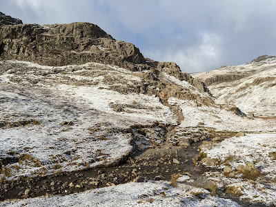 |
| Cross the beck and ascend the rocks opposite |
7NR b. Cross the beck (the difficulty of crossing will depend on the level of water and the iciness of the rocks!) and take the path heading up the rocks on the other side of the valley.
 |
| The first section of steep ascent |
7NR c. After the first section of steep ascent, the route briefly heads more gently over to the left, before it then starts to climb steeply again along the North Rake.
 |
| The start of the main climb up the North Rake |
7NR d. About half way along the North Rake, it's worth heading carefully over to the left to look down over Stickle Tarn, framed by the sides of "Easy Gully", the other prominent rake cutting up the cliffs of Pavey Ark from the tarn below.
 |
| Looking down "Easy Gully" |
7NR e. Continue on up the North Rake, taking care with loose stones and perhaps icy rocks. Don't forget to take in the view behind you, towards Fairfield.
 |
| Looking back down the North Rake, towards Fairfield |
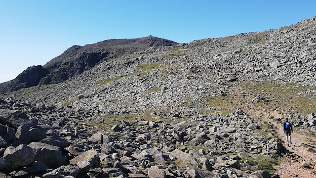
7NR f. After about half-an-hour, the level ground at the top of the rake is reached. Thunacar Knott rises gently in front of you. To your right, across the top of the valley, stand Sergeant Man and High Raise.
 |
| High Raise and Sergeant Man |
 |
Looking towards Thunacar Knott
|
7NR g. Head around and behind the rocks to your left and then up to find the summit rocks of Pavey Ark, overlooking the steep drop down to Stickle Tarn.
 |
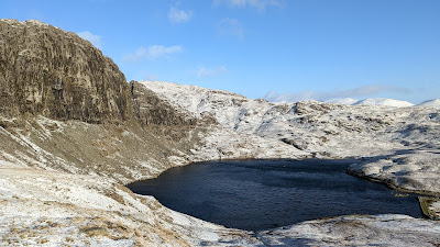
| The view down over Stickle Tarn from the top of Pavey Ark |
8. The summit itself consists of a series of rocky outcrops and terraces. Take your time taking in the view (but don't venture too close to the precipice above the tarn below!)
 |
| Looking east towards Helvellyn and Fairfield |
9. Having got this far, it's worth walking on west to the top of Thunacar Knott, of which Pavey Ark is really just its precipitous edge. Make your way around some small tarns and up the rise that marks the summit of this second fell on the route.
 |
| Walk around the tarns and up the rise of Thunacar Knott |
10. It's not worth spending too long at the summit cairn because, although Thunacar Knott provides the highest altitude of the day (2351'), its rounded slopes do not provide the best views.
 |
| The summit cairn on Thunacar Knott |
11. Rather than rush on, however, it's best to leave the tops of the Langdale Pikes for another hike. So, to complete this circuit, head across the grass south from Thunacar Knott, behind Harrison Stickle, and down into Harrison Combe, the depression between the three main Langdale Pikes.
 |
| Harrison Stickle on the way up the ridge behind Thorn Crag |
12. Again, you have a choice of descents. To return via the 'Pike Howe' route above Dungeon Ghyll, take the path heading east underneath Harrison Stickle. It runs above the gully made by the ghyll, on a rather eroded path in places, then continues down towards Pike Howe on a well paved path, regaining the "PH" route described above.
 |
| The path to Pike Howe skirts above the top of Dungeon Ghyll |
13. For a different route of return, cross over the ghyll and up the ridge between Thorn Crag and Loft Crag. From here, the main path back down to New Dungeon Ghyll is easily found, heading down on a clear path back into Langdale.
 |
| Heading down from the ridge into Langdale |
14. The path winds down above Langdale, to your right, with the valley carved out by Dungeon Ghyll to your left.
 |
| The views from the path descending back into Langdale |
15. The path finishes at the bed of the ghyll, just before the stile that was crossed at the start of the Pike Howe route to Stickle Tarn. It is then a short walk back to New Dungeon Ghyll.
 |
| Looking back from Langdale at the route off the fells. The buttresses in the foreground provide some superb rock faces for serious climbers |
Worth knowing: Jack's Rake is one of the few well-known Lake District walks that is considered to be of sufficient difficulty to be graded as a 'climb', or, to be more precise, a 'Grade 1 scramble', by the British Mountaineering Council.
 |
| Climbers in the Lakes (these are on Dow Crag) |
Of course, for genuine rock climbers, there are far more serious challenges to attempt, both on Pavey Ark and elsewhere in the area of the Langdale Pikes. Well-known climbing rocks in the vicinity include Gimmer Crag, under the 'Wainwright' fell of 'Loft Crag' and, nearby, Raven Crag, above the Old Dungeon Ghyll Hotel.