All sides of Skiddaw
EIGHT Wainwright circular walk: Lonscale Fell, Skiddaw Little Man, Skiddaw, Bakestall, Long Side, Ullock Pike, Carl Side, Latrigg.
Walk Rating:⭐⭐⭐⭐
Time: 7- 8 hours
Parking: free spaces (but arrive early in high season) at the end of Gale Road (Grid Ref: NY 280 825).
 |
| Skiddaw from the A66 north of Keswick |
Of the four 'Wainwrights' that stand taller than 3000 feet, Skiddaw is the easiest summit to reach on foot. As it's also within easy reach of Keswick, Skiddaw welcomes many different Lakeland visitors, both regular mountain walkers and those perhaps wishing there had been a Snowdon-like train to take them to the top!
As Wainwright explains in his guide, Skiddaw's shales and slates have formed gentler, grassier slopes than the more rugged fells carved from the volcanic rocks found across central Lakeland. However, while it lacks dramatic crags, it nevertheless stands tall above Keswick, surrounded by a series of subsidiary peaks. The walk suggested below unashamedly seeks to make the most of the height gained by allowing a circuit of all these peaks, 'bagging' eight 'Wainwrights' in total.
 |
| Strava estimates a walking distance of 21 km |
To Lonscale Fell
1) To shorten what will be a long walk, it's best to start by parking at the end of Gale Road, rather than walking up from the centre of Keswick. Go to the end of the road and head left towards Lonscale Fell. Follow the obvious 'tourist path' alongside the fence, soon reaching the Hawell Monument, a stone cross commemorating a family of shepherds.
 |
| The Hawell Monument with the 'tourist path' behind |
2) Continue up the hillside, to the left of the valley separating you from Lonscale Fell, following the very obvious 'tourist path' (either on this wide, well-engineered track, or by using the steeper old path nearer the fence to its left). Views over Keswick will open up below you.
 |
| Walking up the hillside above the monument |
3) Higher up the hillside, the main path bears left towards Skiddaw. For Lonscale Fell, bear right on a thinner path that continues alongside the fence running above the valley of the Whit Beck, until it reaches the ridge fence at the top of the incline.
Turn right and follow the ridge fence eastwards up to the grassy flat top of Lonscale Fell. There is a summit cairn at the highest point (2344'). If you think you've time, Wainwright recommends also walking a little further, to the east peak of Lonscale Fell, to look down into the Glenderaterra valley.
 |
| On Lonscale Fell, with the onward route clearly ahead |
To Skiddaw Little Man
4) To continue, walk back the way you came onto Lonscale Fell. However, now continue westwards along the ridge fence (it doesn't really matter which side you choose) across the rising slope of Jenkin Hill. Your route will soon meet the main 'tourist path' coming up the grassy slope on the left. Don't take the wide path heading right, directly to Skiddaw, through the gate in the fence. Instead, head up the narrower, but still very distinct, path that continues up the hillside to the left of the fence. This path will take you firstly to the top of the peak known as the "Lesser Man" with its cairn of stones and rusting fenceposts, plus a fine view over Derwent Water.
 |
| On the top of the "Lesser Man" |
5) Walking a little way further uphill, you will reach the higher summit of Skiddaw "Little Man" (2837'). The views, however, are far from 'little', they are perhaps the best of the whole route, looking down over Derwent Water to the high fells beyond.
 |
| The summit cairn of the "Little Man" |
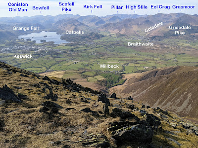 |
| The view over Millbeck and beyond |
Skiddaw
6) From the "Little Man", continue northwards. You will be looking out over Carl Side and Ullock Pike, while Skiddaw itself rises above them to their right. The path heads downwards, into a col, and again runs next to the ridge fence for a short distance.
 |
| Looking out over Carl Side and Ullock Pike |
7) The main tourist path meets the fence from the right, from where it has been skirting underneath the "Little Man". Rejoin this main path and continue up towards the South Top of Skiddaw. You will now be above 3000 feet in altitude as you walk along the stony ridge of the top of Skiddaw.
 |
| You are now over 3000 feet in altitude |
8) The summit ridge runs northwards for about half a mile over a series of tops separated by slight dips. There are a series of cairns and wind shelters too, made out of the slate stones lying across the ridge.
 |
| Looking along the ridge to the main "High Man" top |
9) The main "High Man" top (3053') is clearly indicated by a triangulation column and a separate plaque indicating various landmarks on the horizon (although both may be surrounded by other walkers - hence no photographs of them are on show in this post!).
 |
| The view over Bassenthwaite Lake from the summit |
Bakestall
10) From the top of Skiddaw, for a shorter hike, the descent to Carl Side could now be taken. However, to include a complete tour of the whole Skiddaw Massif, you can opt for a longish detour over the North Top, to also add the subsidiary peak of 'Bakestall' to your itinerary. It does require about three-quarters of an hour's walk downhill, and then at least the same time to come back up. However it's a detour that takes you to the top of another, otherwise rather isolated, 'Wainwright' summit. It's a route that also offers good views of a side of Skiddaw that isn't so often visited, certainly compared to the slopes overlooking Keswick.
 |
| Walk down from the North Top |
11) To continue to Bakestall, walk northwards beyond the North Top, down the steep slope to the 'north col', a lower grassy ridge protruding north from the main body of the mountain. Now look for the fence to your right, and follow the path that runs alongside it, turning steeply down towards Bakestall (2208').
 |
| The path descends the hillside to Bakestall |
12) Strictly speaking, the highest point of Bakestall is at the angle of the fence, where it turns right to descend 'Birkett Edge', down into the valley of the Dash Beck. However, the summit cairns another 100 metres north from the fence provide the best views out over the countryside below.
 |
| Blencathra from the summit of Bakestall |
13) Although not obvious from the way you have reached the summit, Bakestall is undercut on its north-eastern side by the steep cliffs of 'Dead Crags', with the waterfalls of 'Whitewater Dash' underneath them, in the valley below. So, it's worth heading down the hillside a little further to get a glimpse of the valley below.
 |
| The view over the Dash valley towards Knott |
 |
| The 'Dead Crags' beneath Bakestall from the north |
14) A return to Skiddaw again requires you to retrace your steps, back up to the north col above. On the way back to Skiddaw's summit, you will look out over the steep sides of Gibraltar Crag as it cuts into the North Top to your right.
| Gibraltar Crag under Skiddaw's North Top |
15) Return to the summit ridge and walk south to the 'Middle Top' to start the descent to Carl Side. Although the OS map shows the main path as descending from the 'South Top', this is no longer the case.
 |
| Blencathra from Skiddaw's summit ridge |
16) The path from the 'Middle Top' is easy to see, cutting steeply south-west across the rocky western side of the mountain. However, it's not the easiest to walk, particularly in the steepest sections, as the tramp of many feet has left a trail of loose soil that can sometimes slip from underneath you. So, take this path carefully. The fine views give you every excuse to stop and draw you breath!
 |
| Descending to Carl Side |
Long Side, Ullock Pike and Carl Side
17) If you're worried that you're still only halfway through the list of the day's summits, you can be reassured that the ridge below you now provides three named 'Wainwrights' in quick succession. The path down from Skiddaw levels out at a grassy col beneath Carl Side from which you should walk, right, along the ridge.
 |
| The path descending from Skiddaw to the col |
18) A clear and gentle path goes along the top of the ridge of Long Side, reaching a small cairn at its highest point (2405').
 |
| On Long Side |
19) Continuing along the ridge, the path soon takes you to a more distinct high point on the ridge, Ullock Pike (2230').
 |
| Walking along the ridge to Ullock Pike |
 |
| A 'dust devil' on the top of Ullock Pike |
20) Beyond Ullock Pike, the ridge starts to fall away more steeply, down towards the farmland around Bassenthwaite, providing another route to/from the Skiddaw Massif. In this case, however, to complete the circular route, retrace your steps and head back along the path over Long Side, towards Carl Side.
 |
| Return back over Long Side |
21) When you have recrossed the ridge, don't take the path all the way back to the col but bear right on a path that keeps to the higher ground, taking you up the grassy top of Carl Side (2447').
 |
| Skiddaw Little Man and the Helvellyn Ridge from Carl Side |
22) From Carl Side, it's a clear, but long, descent all the way down the path along the south ridge to the quartz outcrop of 'White Stones' and, from there, down to the village of Millbeck. Before you enter the village, take a look back up to Skiddaw Little Man, from where you looked down on Millbeck earlier in the walk.
 |
| Skiddaw Little Man from above Millbeck |
Latrigg
23) Completing the route now requires at least some road walking, although there is a footpath that runs parallel to the road as far as the next village of Applethwaite. From there, make sure to choose the left fork to take the road past the Underscar Manor Hotel and back up to the Gale Road car park. For one last view before you finish, take one of the paths to your right that takes you up the gentle slopes of Latrigg (1203'). Enjoy the views over Keswick and Derwent Water before strolling back to the car park, having hopefully enjoyed a fine day's walking to every side of Skiddaw!
 |
| On Latrigg |
Two of the pages on Skiddaw include diagrams showing how the outline of this peak and its accompanying fells appear differently from different points of the compass. Below are a range of views that show some of those different aspects:
 |
| From Blencathra to the east |
 |
| From Knott to the north-east |
 |
| From Barf to the west |
 |
| From the Whinlatter Pass to the south-west |
 |
| From Over Water to the north-west |
 |
| From High Rigg to the south-east |

