From Easedale to High Raise
FOUR Wainwright circular walk: Blea Rigg, Sergeant Man, High Raise (Langdale), Tarn Crag.
Walk Rating:⭐⭐⭐⭐
Time: 5 - 6 hours
Parking: at Grasmere. Some free spaces on the A591 or paid car parking.
 |
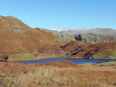
| High Raise and Easedale from Heron Pike |
This circuit from Grasmere up to the top of High Raise provides a stunning walk with a huge variety of scenery. From the charming waterfalls at the start of the walk alongside Sourmilk Gill, this route then climbs Blea Rigg to offer precipitous viewpoints down over Easedale Tarn. It then continues to High Raise, providing very different views westwards towards the high peaks of the Scafells.
The return route suggests you find your own way across the fells from Sergeant Man to Tarn Crag, before descending on a clear path back to Grasmere. It's a route well worth saving for a clear sunny day!
 |
| Strava estimates a total walking distance of around 16 km |
1. Start by heading along the Easedale Road until it bends to the right to cross the sheep pasture by the Lancrigg Hotel. Now leave the road by taking the path crossing the bridge over the Easedale Beck and following the track onwards to the head of Easedale.
 |
| Take the path up the hillside out of Easedale |
2. The path now starts to climb the out of the valley, passing close to some waterfalls.
 |
| The path climbs past a number of waterfalls |
3. The path then climbs alongside the white waters made by the Sourmilk Gill as it rushes down from Easedale Tarn.
 |
| The path climbs next to Sourmilk Gill |
4. The path then reaches Easedale Tarn and skirts around it to the left.
 |
| Easedale Tarn |
5. Instead of continuing on the main path all the way around the southern edge of the tarn, turn left onto a path that climbs steeply up to the side of Blea Crag.
 |
| Looking back as you walk away from Easedale Tarn |
6. Near the top of the incline, you can either continue all the way up to the ridge, or head right, up a grassy rake. Either way, the top of Blea Rigg will be up to your right.
 |
| Choose your way to the top of Blea Rigg |
7. If you prefer to ignore the steep rake, continuing up to the ridge will bring you out onto the path taking walkers to Blea Rigg from Silver How.
 |
| Helvellyn behind you as you reach the top of the ridge |
8. From the ridge path, look for Blea Rigg's summit cairn (1776') on a rocky outcrop to the right of the main path. The views over Blea Crag will be found a little further to the north, beyond the outcrop.
 |
| Climbing the last steps to the cairn of Blea Rigg |
8. If you climb the grassy rake, you will emerge closer to the precipitous viewpoints from the top of Blea Crag. Tread carefully but they are definitely worth a look!
 |
| Looking down from the top of Blea Crag |
9. From the top of Blea Rigg, look for a path that continues north-west up the turf towards Sergeant Man. If you find you are heading downwards, towards Stickle Tarn to the west, you are on the wrong path!
 |
| Looking towards the Langdale Pikes from Blea Rigg |
10. As you head away from Blea Rigg, there are excellent views to your right over both Easedale Tarn and the smaller Codale Tarn and, to your left, down to Stickle Tarn.
 |
| Easedale and Codale Tarns to your right |
 |
| Stickle Tarn and the Langdale Pikes to your left |
11. Keep a look out for a little rockpool that Wainwright noted as being a personal favourite of his.
 |
| Wainwright's favourite rockpool |
12. After a cairned 'crossroads', where you meet the main path that you left on the banks of Easedale Tarn in order to climb to Blea Rigg, the path steepens on its way through crags towards Sergeant Man.
 |
| The path to Sergeant Man |
13. The peaked summit of Sergeant Man can often be seen as a landmark from more distant fells and, as you approach from beneath it, its distinct peak will be seen up to your left.
 |
| Sergeant Man and High Raise from Thunacar Knott |
 |
| The peak of Sergeant Man from below Pavey Ark |
14. As the ridge path gains most of the necessary altitude, the top of Sergeant Man isn't as high above the surrounding ground as you might have expected. The final climb is fairly brief, soon bringing you to the rocks on its summit (2414').
 |
| The Scafells from the top of Sergeant Man |
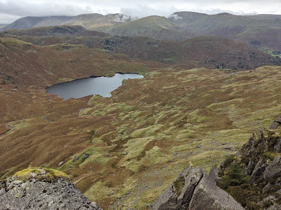
15. From the top of Sergeant Man, you can see that High Raise is actually just a wide grassy plateau, sloping gently to its highest point, about half-a-mile to the north-west. Having spotted your objective, come down from the summit and make your way across the boggy grass towards the top of High Raise.
 |
| A small tarn sits in the middle of the grassy plateau |
16. At the summit itself (2500'), which lies to the west of the grassy top, there's a surprising area of rocks and stones and a triangulation column marking the peak.
 |
| Looking west to the Scafells |
17. Some of the rocks have been turned into a wind shelter. There are excellent views across the Langstrath valley to the high fells beyond.
 |
| The large wind shelter on High Raise |
 |
| The grassy slopes heading down towards Sergeant's Crag |
18. Now retrace your steps south-east towards Sergeant Man, making sure not to head on another path heading south towards Thunacar Knott. From here, you could descend back towards Blea Rigg, and then take the path left, down towards Codale and Easedale Tarns but, in good weather, Wainwright suggests "an interesting test in route-finding", on a higher level route to Tarn Crag.
 |
| "An interesting test in route-finding" |
19. Wainwright's directions will help guide you first north-east, following some old fence posts across Codale Head. As your way starts to descend towards Calf Crag and the top of Far Easedale, you need to bear right, eastwards, down a bumpy ridge towards Tarn Crag. Be careful not to head too close to the edge of Lang Crag, overlooking Codale Tarn on your right. A stream you may have been following eastwards turns sharply south after this crag and drops down into the tarn.
 |
| Looking down over Codale Tarn |
20. Lower down the ridge, a clearer path starts to emerge, where the alternative route coming up from Codale Tarn joins the now narrowing grassy ridge.
 |
| The route up from Codale Tarn |
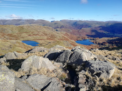
21. Continue along the path and you will reach Tarn Crag at the end of the ridge. The highest point (1801') is up to the left but the best views over Easedale Tarn are from the lower rise to the right of the path.
 |
| Easedale Tarn from Tarn Crag |
22. Walk down from Tarn Crag on the path that descends in the hollow between the two heights. Continue down the long east ridge and then left, following a signpost, down to the footbridge over the Far Easedale Gill at 'Stythwaite Steps'. From here, you can walk back to Grasmere along the old lane that runs underneath Helm Crag.
 |
| Walking off Tarn Crag |
Worth knowing: For an area so filled with hills and mountains, as well as different linguistic influences, it's not surprising that there are so many different words used to name fells of different shapes and sizes. For example, you will find Knotts, Pikes, Hows, and Dodds, as well as Fells.
On this walk, it's fairly clear why 'Tarn Crag' got its name. 'High Raise', like its namesake in the Far Eastern Fells, is a high fell without a prominent peak. 'Blea Rigg' is likely to mean 'blue ridge', one of several more elongated 'Riggs' to be found in the list of Wainwright Fells. The 'Man' in 'Sergeant Man', like those to be found on Helvellyn, Skiddaw and Coniston, is not a person but a stone or rock, from the Brythonic 'maen'. The word 'menhir', for a standing stone, comes from the same root.
 |
| Looking up towards High Raise from below Blea Rigg |

