The Central Ridge
THREE Wainwright circular walk: High Tove, High Seat, Armboth Fell.
Walk Rating:⭐⭐
Time: 3 - 4 hours
Parking: at the pay-and-display Armboth Car Park (Grid Ref: NY305172).
 |
| High Seat and the central ridge from above Wythburn Church |
The central ridge of Lakeland fells, running northwards from Ullscarf towards Keswick is not the most popular area for hikers. That's because this wide grassy watershed probably provides the most consistently wet ground that you can find to walk upon anywhere in the Lake District!
This is therefore probably a route mainly to be left for determined "Wainwright baggers" although it does provide a fine view northwards over Keswick from the top of High Seat.
 |
| Strava estimates a walking distance of 9 km |
1. Walk up the footpath, signposted to Watendlath, that starts from the reservoir road, just north of the Armboth car park. It crosses a bridge and climbs up to the northern side of the valley carved out by Fisher Gill.
 |
| The path climbs to the side of wooded Fisher Gill |
2. Keep climbing on the clear path with the wooded banks of the gill to your left.
 |
| Looking back towards Thirlmere and the Helvellyn ridge |
3. The path emerges onto the open ground above the trees and bears away from the gill towards the top of the grassy ridge above. This is the first point where you will be testing how good your boots are as you walk across the soggy grass!
 |
| Walk across the grass towards High Tove |
4. High Tove (1690') is really just a slight rise in the long central ridge but, nevertheless, boasts a prominent summit cairn.
 |
| The cairn at the top of High Tove |
5. Walkers continuing onwards to Watendlath now continue westwards, through the gate in the fence running along the ridge. For our route, you should now turn northwards and follow the line of the fence along the ridge to High Seat.
 |
| Walk north along the ridge to High Seat |
6. You will come to a particularly wet area where the fence runs through some sodden peat hags and pools that will require some ingenuity to find the best way to cross!
 |
| Pick your way through the peat hags as best you can |
7. Once beyond this particularly wet patch, the going becomes easier as the path follows the eastern side of the fence to the top of High Seat (1995').
 |
| Follow the fence to the top of High Seat |
8. The summit has a Ordnance Survey column and, in late summer, is covered in heather.

 |
| The summit of High Seat |
9. There are good views in all directions, but particularly northwards. On a fine day, you can see the Scottish hills beyond Bassenthwaite Lake.

10. If you are harbouring any thoughts of continuing along the ridge towards Bleaberry Fell, take heed of Wainwright's warning that the boggy conditions make this "a walk to wish on one's worst enemy, especially after rain" ! To add an additional "Wainwright" to your day, it's best to retrace your steps across the peat hags to High Tove and, from there, follow a path across the grass south-east to Armboth Fell (1570').
 |
| On top of Armboth Fell |
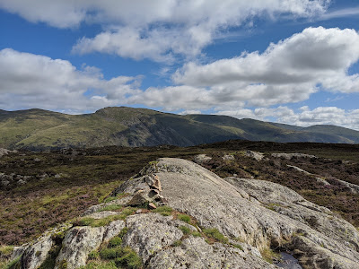
11. Armboth Fell consists of some slightly elevated ground sitting between the central ridge and the forested sides of Thirlmere. After so much walking across marshy ground, its dry rocky summit is very welcome. Helvellyn can be seen to the east.
 |
| Looking eastwards towards Helvellyn |
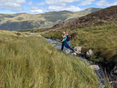
12. To return to Armboth and the start of the route, choose one of various routes that walkers have taken northwards across the marshy ground alongside the top of Fisher Gill. Find your way across the stream and rejoin the main path.
 |
| Cross the top of Fisher Gill |
13. Head back down the main path, alongside the wooded valley of Fisher Gill, back down to the road above Thirlmere.
 |
| Head back down the path towards Thirlmere |
Worth knowing: The minor road around the western side of the Thirlmere reservoir provides access to a number of car parks for holidaymakers visiting the area. In the summer, they are well used by canoeists and kayakers as well as by walkers.
The road also offers a much nicer route for cyclists heading to/from Dunmail Raise than the main road on the eastern side of Thirlmere.
 |
| On the cycle path from Dunmail Raise |

