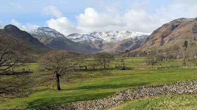
Crinkle Crags
ONE Wainwright walk: Crinkle Crags
Walk Rating:⭐⭐⭐⭐
Time: 6 - 7 hours
Parking: At the roadside (but not blocking passing places!) at the top of Wrynose Pass.
 |
| Crinkle Crags from Great Langdale |
Rather than try to repeat what Wainwright has already set out, and because the route across the crags is fairly easy to follow, I will keep this post relatively short. However, hopefully the photographs will entice you into trying this walk for yourself - especially as my suggested starting point of Wrynose Pass means your car will have done some of the initial climbing that you would otherwise have to walk if starting out elsewhere.
 |
| Strava estimates a walking distance of 10km - there and back |
1) Starting out just above the 'Three Shire Stone' on Wrynose Pass, take the path that ascends the hillside northwards, up to Red Tarn, which sits in the col between Cold Pike and Pike o'Blisco.
 |
| Crinkle Crags lie ahead, beyond Red Tarn |
2) At a junction of routes just beyond Red Tarn, turn left and take the path that traverses over the northern slopes of Cold Pike. The clear path takes you upwards across the grassy slopes to the west of the rocky crag of Great Knott.
 |
| Looking across the grassy slopes to the Langdale Pikes |
3) After a little more than 3 km of walking from Wrynose Pass, the grassy slopes finish. You have arrived at the rocky ridge of Crinkle Crags. However, before climbing up the first Crinkle, take a detour right to look at the view across 'Great Cove' towards the second and third Crinkles.
 |
| Looking across Great Cove to the second and third Crinkles |
4) Now take the path that climbs through the rocks to the first Crinkle (2733').
 |
| Climbing up the first Crinkle |
5) Descend on the far side into a small grassy depression. Then, unless you want to try the 'Bad Step' (see 9 below), take the path that skirts left around the foot of the second Crinkle before ascending up a stony rake to reach a small tarn at the top.
 |
| Ascend the second Crinkle on the stony rake to the left |
6) Beyond the tarn, head east a short way across the rocky top to find the summit cairns. This second crag is the highest point of the ridge and therefore provides the official summit (2816').
 |
| The Scafells beyond the tarn on the second Crinkle |
 |
| On the official summit of Crinkle Crags |
7) Now take the path that continues across the scree gully of Mickle Door to traverse the remaining three Crinkles. To reach the summit cairn of the third Crinkle (2740'), you will need to walk 50 metres over to the right of the path. Continue to the fourth Crinkle (2730') and the rocky fifth Crinkle, also known as Gunson Knott (2680').
 |
| Bowfell and Shelter Crags from the last Crinkles |
8) It's worth walking further along the ridge towards Shelter Crags to take in the view along the final part of the ridge towards Bowfell. However, when you have walked as far as you want, simply reverse the traverse and walk back across the Crinkle Crags in the other direction.
 |
| Bowfell and the Three Tarns col from Shelter Crags |
9) When you return to the grassy depression beyond the highest Crinkle, a walk to your left will allow you to look up the gully that provides an alternative direct route up to its summit. But, as you will see, this ascent requires finding your way around a 10 foot rock wall known as the 'Bad Step'. Try it if you like!
 |
| The 'Bad Step' |
10) A little energy can be saved by taking the path that skirts across the grass around the western side of the last Crinkle. From there, return along the clear path down to Red Tarn, and then back to Wrynose Pass.
 |
| The view into Langdale from beneath the 'Bad Step' |
Worth knowing: A tall column known as the "Three Shire Stone" used to stand on Wrynose Pass, inscribed with the word 'Lancashire'. It marked the point where the old county boundaries of Lancashire, Cumberland and Westmorland met in one place. Sadly, in 1997, the stone was smashed, perhaps by a car colliding into it.


