TWO Wainwright circular walk: Pike o'Blisco and Cold Pike
Walk Rating:⭐⭐⭐
Time: 3 - 4 hours
Parking: Limited free spaces on the side of the road winding up from Great Langdale to Blea Tarn, or use paid parking at Old Dungeon Ghyll. Alternatively, take the 516 bus from Ambleside.
 |
| On the summit of Pike o'Blisco |
Pike o'Blisco and Cold Pike are two fells that can be overlooked by walkers starting out from Dungeon Ghyll, as they perhaps struggle to compete in interest with the iconic Langdale Pikes on the other side of the valley.
However, both peaks are still well worth climbing. Pike O'Blisco offers an interesting summit, with excellent views over Bowfell and Crinkle Crags. Cold Pike marks the end of that ridge of fells, before it drops away into the Wrynose Pass. Both fells can also be climbed via routes starting at the pass, reducing the amount of ascent required on foot - but not by your car!
 |
| Strava estimates a total walking distance of 10km |
1. Starting at Old Dungeon Ghyll, walk along the main road past the side entrance to the National Trust campsite towards the farm at Wall End. Pike o'Blisco will be rising in front of you, forming the southern rim of the end of Great Langdale.
 |
| Looking along Oxendale near Wall End farm |
2. After the farm, the road turns left and then steeply climbs the hill alongside Redacre Gill. This is also where you may have been lucky enough to find some free roadside parking. As the gill bends away from the road, walk up a little higher and you will see a clear path leaving the road to the right, above the gill. This is the path to take to Pike o'Blisco.
 |
| Leave the road above the gill on the clear path on the right |
3. The path heads up the side of the fell with the Langdale Pikes behind you.
 |
| The path climbs the fell |
4. When the path reaches the stonier higher slopes, cairns mark the onward route to the summit above. Bowfell and the Langdale Pikes can be seen to your right.
 |
| Follow the cairned path to the top of the fell |
5. The last part of the ascent will need you to pick a route through the rocks to reach, firstly, the south-eastern summit.
 |
| Looking back to Langdale from the south-eastern summit |
6. The true summit stands just a little further, with the summit cairn sitting on a rocky outcrop (2313')
 |
| Walking to the true summit cairn |
 |
| On the summit of Pike o'Blisco (2313') |
7. There are excellent views from here towards Crinkle Crags and back over the lower south-eastern peak towards the Coniston Fells. If needed, you can also make use of the wind shelter that has been built out of the stones beneath the summit.
 |
| Above the clouds on Pike o'Blisco |
8. To the north-east stands the Langdale Pikes with the Helvellyn ridge in the distance.
 |
| The Langdale Pikes from Pike o'Blisco |
9. To continue towards Cold Pike, take the cairned path that drops from the south-west of the summit down to a junction of paths just to the north of Red Tarn.
 |
| On the path between Pike o'Blisco and Cold Pike |
10. Don't try and head straight up the steep side of Cold Pike on the other side of the hollow containing Red Tarn but, instead, take the paved path heading across the northern flank of Cold Pike, heading towards Great Knott, the minor peak walkers pass on their way to Crinkle Crags.
 |
| Great Knott to the right of the path up from Red Tarn |
 |
| Looking back to Pike o'Blisco from the same point |
11. When you have passed the head of the steep valley taking a gill down the fellside in front of Great Knott, it's time to leave the main path. Head across the grass on your left, turning back on yourself slightly, towards the top of Cold Pike. There's only a sketchy path but you should be able to easily find your way across the grass on a fairly easy gradient, before ascending the rocky outcrops of the summit itself (2300').
 |
| The summit cairn on a cold Cold Pike |
 |
| Looking through the clouds to the Coniston Fells |
12. If you want to take a different route off Cold Pike, you can make your way around the crags to its south and east and then down the fellside towards Red Tarn.
 |
| Heading down the fellside towards Red Tarn |
13. Make your way to the junction of paths to the north of Red Tarn that you crossed earlier on your way down from Pike o'Blisco. This time, take the path that heads north down into the valley of Oxendale.
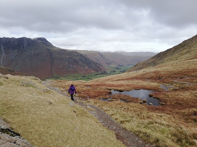 |
| Heading down into Oxendale |
14. Follow the clear path downhill and then along the side of the Oxendale Beck until you reach the Stool End farm road. Walk along the farm road back to Dungeon Ghyll.
 |
Follow the farm road back to Dungeon Ghyll
|
 |
| Looking back at Pike o'Blisco in spring sunshine |
Worth knowing: When you're walking high above Langdale, the scenery can seem idyllic. Unfortunately, this fantastic countryside has attracted so many second-home owners that it has driven house prices out of the reach of most local people.
 |
| Lawn mowers come free in Chapel Stile |
Chapel Stile, the village that visitors pass through on the way to Dungeon Ghyll now consists almost entirely of second homes and holiday lets. A 2014 survey estimated that 70% of the housing was no longer regularly occupied by long-term residents. By 2022, that figure was now estimated to be as high as 90%.


