TWO WAINWRIGHT walk: Slight Side and Scafell
Walk Rating:⭐⭐⭐⭐
Time: 6 - 7 hours
Parking: limited free spaces in the small car park on the roadside opposite Wha House Farm (Grid Ref: NY 200 009)
 |
| Slight Side, Scafell, Scafell Pike and Great End from Hard Knott |
As the second highest mountain in England, standing only a little lower than its near neighbour, Scafell Pike, Scafell is a mountain that every keen walker will want to climb. The route described here is probably the nicest way to do so.
Scafell can be climbed from the north, but, while this approach shows off the mountain's crags in all their magnificence, a difficult ascent through those crags is then required. This southern approach to Scafell from Eskdale, via Slight Side, is a much easier approach, with both summits offering fine panoramas. The "Terrace Route" at the start of the walk also provides attractive scenery from a lower altitude.
 |
| Strava estimates a walking distance of 13km with a 930m elevation gain |
1. Starting from the car park near the Wha House Farm, cross the fence and take the path leading up the hillside.
 |
| Walk up the hillside from the Wha House car park |
2. The path goes through a gate, follows a wall up the hillside and then continues onto a "terrace" of gently rising ground, between rocky outcrops. This is why the path is named the "Terrace Route" in Wainwright's Guide.
 |
| The path crosses this scenic "terrace" |
3. The path reaches the little 'Catcove Beck', bending through the bracken and grass in front of the outcrop of 'Cat Crag', before it flows into the valley to the east. Keep to the left, along the side of the beck, then cross it once you are beyond the gap between Cat Crag and another rocky knoll to its left.
 |
| Walk to the left of Catcove Beck and Cat Crag |
4. The next section of the route can be a little boggy, but it's generally best to keep to the slightly higher ground to the left. Whatever your exact choice of route, you will be fine as long as you keep making your way towards the summit of Slight Side, rising in front of you.
 |
| Skirt to the left of the marshier ground ahead |
 |
| Head towards the summit of Slight Side |
5. The path passes beside a 'big boulder' (as it is described in Wainwright's Guide) before starting on the steeper final drag up to the top of Slight Side.
 |
| The steeper climb starts soon after this prominent rock |
6. The summit of Slight Side has a fine rocky ridge that has to be clambered up in order to reach its highest point (2499').
 |
| Approaching the summit ridge on Slight Side |
 |
| Looking out from the top of Slight Side |
7. There is a fine panorama stretching from distant Haycock, past Scafell to the north, all the way around to Bowfell and Crinkle Crags.
 |
| A panorama to the north of Slight Side |
8. To the west, you can look down at Whin Rigg and Illgill Head, just about hiding the concrete of Sellafield on the western coastline. Burnmoor Tarn sits in front of Illgill Head, and the top of Wast Water can be spotted behind it.
 |
| Looking westwards towards Illgill Head |
9. To continue to Scafell, continue northwards, across some flatter, rock-strewn, ground and then up the steeply rising ridge ahead.
 |
| Walk across this rock-strewn area then up the ridge ahead |
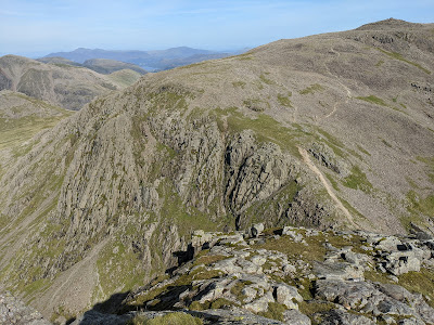
10. From this ridge, marked 'Long Green' on the OS Map, you can peer down over the steeply falling ground to the east of Scafell.
 |
| Scafell and Scafell Pike from the 'Long Green' ridge |
11. Continue onwards along the ridge, and then up a final stretch of steeper fellside, to reach the rocky summit of Scafell itself (3162').
 |
| The summit cairn of Scafell |
12. As you might expect, there are excellent views to be had in all directions from the summit cairn.
 |
| Skiddaw and Blencathra in the distance, left of Scafell Pike |
 |
| Illgill Head, Wast Water and the western coastline |
 |
| The line of peaks to the east |
13. Walking beyond the summit, across the grassy saddle to the north-east, will take you to the top of the crags looking out over Mickledore and the Pulpit Rock.
 |
| Looking down over Mickledore |
14. On the north of the crag, the rocky outcrop of Symonds Knott rises to the left of the deep cleft of Deep Gill.
 |
| Symonds Knott and Deep Gill |
15. When you have finished at the summit, return towards Eskdale by the same general route that you came up. However, in descent, it's possible to by-pass some of the 'Long Green' ridge by cutting across its western flank directly towards the rock-strewn flatter ground to its south, before descending beneath Slight Side.
 |
| Cut down the side of the ridge to this flatter area |
16. After 'Cat Crag', make sure to keep on the higher ground towards the 'Terrace', and not try and follow the Catcove Beck down into the valley.
 |
| DON'T be tempted to follow the course of the Catcove Beck |
17. As you return along the 'Terrace Route', there are good views east across the top of Eskdale to the Hardknott Roman Fort, on the shelf of land opposite, with the steep turns of the road to Hardknott pass rising behind it.
 |
| Looking east towards Hardknott Roman Fort and Pass |
18. Your final views will be across to Harter Fell, before you return down the final stretch of fellside to the road and car park above Wha House Farm.
 |
| Harter Fell from The Terrace |
Worth knowing: Lord's Rake and the West Wall Traverse provide alternative routes to the top of Scafell, but require walking up scree slopes through the steep crags on the north of the mountain. If you are considering these approaches, do take a look at other sites that explain these routes - and their dangers - in more detail. However, the photographs below give you some idea of where to find them:
 |
| The climb to the bottom of Lord's Rake from 'Hollow Stones' |
Lord's Rake is first accessed by climbing up a long scree-covered slope from the area known as 'Hollow Stones'. This is reached by the main tourist path to Scafell Pike from Wasdale Head. Lord's Rake is a long straight scree gully that then ascends to the right from the top of the first scree slope.
 |
| Lord's Rake highlighted in the view from Mickledore |
Instead of scrambling all the way to the top of Lord's Rake, after climbing most of the first section of the rake, an alternative path can be taken to the left across a grassy shelf. This is known as the West Wall Traverse.
 |
| The routes as seen from the south peak of Scafell Pike |
The West Wall Traverse path leads to the cleft of Deep Gill which must then be climbed up to reach the top of the mountain, the route emerging below Symonds Knott.
 |
| Looking down Deep Gill, with Mosedale behind |

