ONE Wainwright circular walk: Castle Crag.
Walk Rating:⭐⭐⭐⭐
Time: 2 - 3 hours (depending how long you take exploring caves and quarries!)
Parking: a few free spaces in Grange on the parking area in front of the church, just over the bridge crossing the river (Grid Reference: NY 254 175). You can also take the bus that runs regularly from/to Seatoller, through Borrowdale, to/from Keswick.
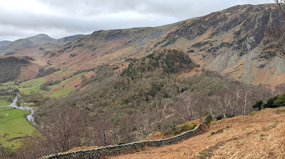 |
| Castle Crag from King's How |
Why should a small hill, the only one of the Wainwright fells under 1000 feet in altitude, be such a favourite amongst visitors to the Lake District? Perhaps, because, as Wainwright puts it in his Guide to the North Western Fells, it stands "in the author's humble submission ...(in) the loveliest square mile in Lakeland - the Jaws of Borrowdale".
This short walk around Castle Crag takes you along a riverbank, through beautiful woods, and up to the fine summit viewpoint where, in spite of its low altitude, you can see Scafell Pike, Helvellyn and Skiddaw. But the route also visits some of the best of the caves and quarries of Castle Crag, so that you see this beautiful little fell not just from above, but from below as well!
 |
| Strava estimates a walking distance of 7km |
1) Start by standing on the bridge over the River Derwent at Grange. Castle Crag is the small hill to the south, above the river, dwarfed by Low Scawdel, the craggy fell that rises up to the top of High Spy to the west.
 |
| Castle Crag, dwarfed by Low Scawdel |
2) Walk through the village and then turn left along the minor road, just beyond the Grange Cafe. The bridleway sign points towards Rosthwaite and Seatoller.
 |
| Turn left and walk along this minor road out of the village |
3) Walk along the road. The long ridge between High Spy and Maiden Moor will be above you.  |
The view on a day when the higher fells are in cloud!
|
4) At a junction of minor roads, bear left, now signposted for Castle Crag.
5) The road passes a campsite then becomes a track heading down to the wooded riverbank.
 |
| Head down the track to the wooded riverbank |
6) Walk around the slight bend in the river, using the footbridges provided to cross the two small streams flowing across the stony riverbank.
 |
| The first of the two footbridges |
7) Walking up the slope beyond the second footbridge, you will come to a signposted junction. For the most picturesque route, take the path that continues ahead, above the river, rather than the track heading right directly towards Castle Crag. This will be our return route instead.
 |
| Head straight at the junction, to walk above the river |
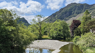
8) The path guides you through the Low Hows woods, along the banks of the Derwent, with its crystal-clear waters flowing below you.
 |
| Walking along the side of the River Derwent |
9) The clear path continues through the woods, crossing a stone wall, heading uphill away from the river.
 |
| Follow the path away from the river |
10) Look out for a junction where a thinner stony path, leaving the main path on the right of a bend, climbs up to the fellside towards some caves and spoil heaps above. This is a detour that is definitely worth taking.
 |
| Take a detour up this path on the right |
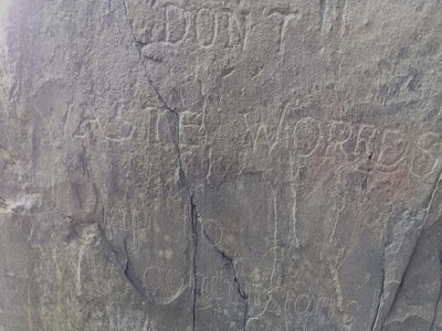
11) Follow this path upwards until you reach the highest pair of large caves above. These are Millican Dalton's caves, for many years used as a summer residence by this pacifist mountaineer and adventurer who escaped his life as an insurance clerk in London to become 'a gentleman of the hills'.
 |
Millican Dalton's Caves
|
12) Dalton called the smaller cave, to the right of the main cave, 'The Attic' and used it as his sleeping area. Carved on the rock outside this higher cave, on the left of the entrance, is lettering saying, intriguingly, "Don't!! Waste words Jump to conclusions!" - presumed to be by Dalton. Less well publicised, to the left of the main cave, are the words "Good, Comrade". Dalton certainly had left-wing views.
 |
| The carved letters to the left of the main cave |
 |
The carved letters at the entrance to the 'Attic'
|
 |
Looking into the main cave from the 'Attic'
|
 |
| Looking out of the main cave towards Grange Fell |
13) Now return to the main path (there is no safe route up to the summit beyond the caves). The clear path continues south through the woods, heading closer again to the river. Ignore further side paths and continue on the track until it reaches a gate, situated at the point where the woods open onto the farmland to the south of the fell.
 |
| Go through the gate and then, soon after, through another on the right |
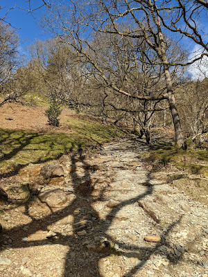
14) Go through the gate and then, 100 yards later, go through a further gate in the fence alongside the track, to enter the field to the right. Now walk up the field on a path that soon becomes very clear, and largely paved, as it heads up through the woods towards the summit of Castle Crag.
 |
| Follow the path up the hill into the woods |
 |
| Looking south towards Rosthwaite as you climb into the woods |
15) On the way up the hill, there's another little detour, less well known, which should also not be missed. On your left, look out for a little stone hut. Walk over to the hut from the path, and then look a little further around the hillside beyond the hut where you should see a little gully filled with holly trees.
 |
| The gully lies in the trees just beyond this stone hut |
16) If you walk over to find the small stream at the end of the gully, you will soon work out that the water that is flowing out of an old mining level carved out of the rock beneath the fellside.
 |
| Heading into the old level |
17) Although the floor of the level is flooded, it's not very deep and some well-placed stepping stones allow you to walk into the level for perhaps ten yards or more. Definitely go and take a look - but paying due care and attention of course!
 |
| Inside the level |
18) Now return to the main path and head further up through the trees towards the top of the fell.
 |
| Walk up the wide path through the trees |
19) The path goes through another wall into the more open ground that lies beneath the summit of the fell.
 |
| The path continues up across this more open ground |
20) Now cross the next wall using the large (and new) ladder stile up to your right. You will emerge at the bottom of the large pile of spoil that lies between you and the summit of Castle Crag.
 |
| Cross the next wall using the ladder stile |
21) Walk up through the spoil on the clear and well-maintained path that zig-zags up to the level ground at the top of the spoil heap.
 |
| Walk up the path that zig-zags up to the top of the spoil heap |
22) From here, you can explore the old quarry to the left, just beneath the summit, where the old stones have been piled by visitors into various small cairns and sculptures.
.jpg) |
| In the quarry (in the rain!) beneath the summit |
23) Now climb to the summit on the clear path that climbs up between the larch trees to the right of the quarry. There is no other safe route to the top!
 |
| Looking into the quarry near where the path climbs onto the summit area |
24) For such a small fell, Castle Crag has an impressive summit, a circular area bounded by steep drops on all sides (which was, indeed, probably once a hill fort). The summit provides good views in all directions. The best view is north, over Derwent Water towards Skiddaw and Blencathra, but Helvellyn and the Scafells can also be seen from the top of the fell as well.
 |
| Looking north over Derwent Water |
 |
| Looking south-west over the quarry to the Scafells |
25) The summit cairn sits on an outcrop of rock, to the side of which is attached a memorial to soldiers from Borrowdale who died in the First World War. The first name on the plaque is that of Second Lieutenant John Hamer, in whose name the land at the top of Castle Crag was donated to the National Trust in 1920.
 |
| The rock supporting the plaque and summit cairn |
 |
| The memorial plaque at the top of Castle Crag |
26) Now make your way back down the path besides the quarry and then along the zig-zag path down the spoil heap below it.
 |
| Take the path back down down the spoil heap |
27) The path descends further, towards the valley to the west of Castle Crag, passing beneath a further bank of spoil.
 |
| Descend into the valley beneath further banks of spoil |
28) The clear path bends sharply left to descend to the valley below from where you can then follow the old paved road back north towards the banks of the River Derwent and, from there, walk back along the tarmac road to Grange. |
| Take the old road along the valley back towards Grange |
Worth knowing: To complete your tour of Borrowdale, it's worth visiting the "Bowder Stone", a huge boulder perched on one of its corners in the ground beneath King's How, on the opposite side of the Derwent from Castle Crag. It probably landed in this position having fallen from Bowder Crag, 200 metres above.
It was developed as a tourist attraction as long ago as 1798 by Joseph Pocklington, who set up ladders allowing his clients to climb to the top of the rock. The latest metal ladder, put in place to allows visitors to ascend, was installed in 2019.


.jpg)


