THREE Wainwright walk: Grisedale Pike, Hopegill Head, Whiteside.
Walk Rating:⭐⭐⭐⭐
Time: 3 - 4 hours (plus time for the bus journey from Lanthwaite to Whinlatter)
Parking: use the free parking area by Lanthwaite Green Farm (Grid Reference: NY 159 207) before taking the 77A bus to Whinlatter Forest Park, where the walk begins.
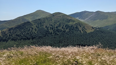 |
| Grisedale Pike, Hobcarton End and Hopegill Head from Whinlatter |
This route links three fantastic peaks in one walk, and is one of my favourite medium length hikes. All three summits are easy to identify from a distance because of their shape and position. The views from their summits, and along their interconnecting ridges, don't disappoint either.
The way to combine these peaks in one easily manageable walk is to take advantage of the summer bus timetable. Parking you car in Lanthwaite and then taking the bus to the start of the walk on the Whinlatter Pass means you only have to walk one-way - and your car will be waiting to take you home at the end of what should be an excellent hike.
 |
| Strava estimates a walking distance of around 9km |
1) Lanthwaite Green Farm stands at the side of the road that runs alongside Crummock Water, south into Buttermere. There is a small free parking area just to its south where you can leave your car and look up at the rising slopes of Whiteside and Grasmoor immediately to the east.
 |
| Whiteside from the car park at Lanthwaite Green |
2) Make sure to check the bus timetable beforehand and arrive in time to be waiting to hail the first 77A bus of the day, coming up the hill alongside Crummock Water (in Summer 2022 this departed from Buttermere at 09.24).
 |
| Look out for the bus as it comes up the road from Buttermere |
3) After half-an-hour's ride via Low Lorton, you will arrive in the car park of the Whinlatter Forest Park. Jump out and walk a little further down the road to the Revelin Moss Car Park where the walk properly begins.
 |
| The forest at Revelin Moss |
4) You need to find your way from the car park through the forest, then onto the open fellside at the foot of Hobcarton End. To do so, take the lower track at the entrance to the car park, across the Sanderson Gill.
 |
| Take this track below the car park |
5) About 200 metres later, you reach a junction of forest tracks. Take the track heading up to the right and then, only about 50 metres later, take the path going up the slope through the trees to the left of the track.
 |
| Take this path on the left through the trees |
6) Follow the path uphill and the trees will start to thin until you emerge on the fellside amongst bushes of heather and bilberries. The summit of Grisedale Pike will be away to your left. (Update - Forestry work in 2022 has bulldozed some additional tracks through the trees across the course of the walking route, but keep making your way uphill until you find the clear path on the fellside above the forested area).
 |
| Emerge onto the fellside amongst heather and bilberries |
7) Now follow the path that heads south-west up the steep ridge of Hobcarton End. There are excellent views down onto the Whinlatter Pass road, in the valley to your right.
 |
| Looking down onto the Whinlatter Pass road |
8) Once at the top of the initial climb, the gradient becomes a lot easier as you walk, now southwards, along the north ridge of Grisedale Pike, towards its summit.
 |
| Walk along the ridge towards the summit of Grisedale Pike |
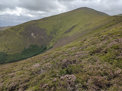
9) As you gain height, gently at first, then more steeply towards the summit, there are excellent views out to your right, both of Hobcarton Crag at the head of the valley, and of the summit of Hopegill Head, to the right of those crags.
 |
| Hobcarton Crag and Hopegill Head will be to your right |
 |
| Whiteside appears behind Hopegill Head as you climb higher |
10) You will join another path coming up Grisedale Pike's north-east ridge, and then you will soon be on its rocky summit (2593'). There are excellent views in all directions.
 |
| Looking along Coledale towards Skiddaw and Derwent Water |
11) The onward route continues on a clear path along the stony ridge to the west, first heading down to a depression and then, after rising over a subsidiary summit, down to the col above Hobcarton Crag.
 |
| Follow the path westwards down the ridge .. |
 |
| ... and then up the subsidiary summit to the west |
12) Take your time to take in the views as you walk along the ridge.
 |
| Hopegill Head from Grisedale Pike |
 |
| Hopegill Head from the col above Hobcarton Crag |
13) After the col, the path heads up a grassy slope to the summit of Hopegill Head 2525'). The grassy subsidiary peak of Sand Hill will be visible to your left. It provides a sharp contrast to the peak of Hopegill Head, which is a rocky platform on the edge of a precipitous drop.
 |
| Grisedale Pike from Hopegill Head |
14) The walk to Hopegill Head is not the last high-level ridge walk on this route! Continuing west leads you along a further grassy ridge which then becomes a rocky traverse. There are striking views along the valley of the Gasgale Gill, down towards Crummock Water.
15) The ridge widens a little and the path skirts above the grassier slopes to the right. The route climbs, firstly, to Whiteside's east top (this is actually the higher one!) and, then on to the cairn at the end of the ridge that marks the 'official summit' of Whiteside (2317').
 |
| Looking back along the ridge from the top of Whiteside |
16) The summit cairn gives good views of the surrounding fells, but for the best views down over Crummock Water, walk across the grass to a lower viewpoint, 300 yards further west, on the top of Whiteside End.
 |
| Mellbreak and Crummock Water, below Whieside End |
17) The final descent of Whiteside is down a steep path from the summit along its south-western ridge. As the path winds to the left, look out for the good views back up the valley towards Hopegill Head, and the Coledale Hause col at the head of the valley.
 |
| Looking back up the valley to Hopegill Head and Coledale Hause |
18) It's an interesting, but lengthy, descent, the path heading down through heather, juniper and bilberries. The route descends firstly to the top of the little hillock of Ben Whin, and then drops down steeply again, bringing you out at the Liza Beck, the stream that flows out of the deep valley between Whiteside and Grasmoor.
 |
| Looking back up the heathery slope of Whin Ben |
19) Cross the beck on the footbridge and then it's only a short stroll back to the car park at Lanthwaite Green.
 |
| Grasmoor over the Liza Beck |
Worth knowing: If you have browsed through Lakeland postcards and guide books, you may well have come across pictures of a farmer's sign, written in Cumbrian dialect, saying "Tek Care. Lambs Ont Road". Well, Lanthwaite is the place to take your own picture!
The clearest sign is on a post about a mile further down the road towards Rannerdale. However, the most picturesquely positioned sign, even though the lettering is now rather faded, can be found by the cattle grid just a hundred yards or so up the road from the Lanthwaite Green car park.
 |
| The sign on the cattle grid at Lanthwaite Green |


