TWO WAINWRIGHT circular walk: Scafell Pike and Lingmell
Walk Rating:⭐⭐⭐⭐⭐
Time: 5 - 6 hours
Parking: at Wasdale Head - free spaces available on the Green (Grid Ref: NY 187085) or paid spaces at the National Trust Lake Head Car Park (Grid Ref: NY 182075)
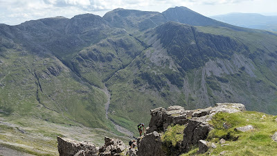 |
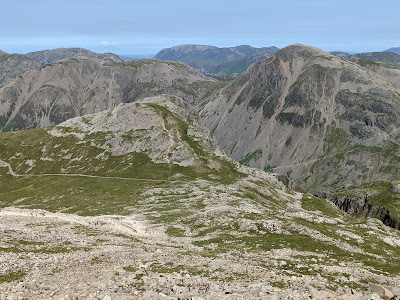
| Scafell Pike and Lingmell from Great Gable |
Scafell Pike, as the highest mountain in England, rightly attracts thousands of walkers each year, all determined to reach its summit. Most ascend by the relatively straightforward paved 'tourist path' from Wasdale Head, although not all who start fully recognise that 3000 feet of ascent requires some preparation, even if walking on a clear path! Lingmell, lying close to that path, is also a summit well worth climbing, with magnificent views out over Great Gable and beyond.
There are, however, definitely more interesting choices of route to Scafell Pike than via the main 'tourist path'. I have outlined briefly the ascent from Esk Hause - passing beside Great End, Ill Crag and Broad Crag - at the very end of this post. The route I have described in detail, however, starts on the main path up 'Brown Tongue' but then climbs to Scafell Pike via a far more dramatic ascent onto Mickledore. After descending to Lingmell, I suggest two alternative descents, both full of interest, one above Piers Gill and the other along the 'Corridor Route'. As a day's outing in Lakeland, this has to be one of the best.
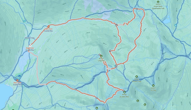 |
| Strava estimates a walking distance of around 14km, but with over 1000m of ascent |
1. Starting at Wasdale Head Green, walk south to reach the bend in the road, then take the path left, across a field, heading towards the ridge of Lingmell (not the one signposted to the campsite). The path soon crosses the wide bed of the Lingmell Beck on a footbridge.
 |
| Crossing the Lingmell Beck (in a dry summer!) |
2. The path now climbs diagonally across the flank of the fell before turning eastwards to follow the well-trodden path that takes walkers up the valley of the Lingmell Gill. The route from the Lake Head Car Park joins from the right. The path climbs along the northern side of the Lingmell Gill before crossing it and heading up 'Brown Tongue', after which this route is named.
 |
| Crossing the Lingmell Gill |
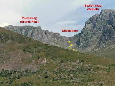
3. The obvious and well paved path climbs steeply towards the area known as 'Hollow Stones'. The impressive crags of Scafell and Scafell Pike rise up above this hollow. When the path starts to reach the first of those crags on the right, Black Crag, fork right on the thinner but clear path heading towards Mickledore (and to Lord's Rake for those taking this dramatic route to Scafell).
 |
| Take the right fork under Black Crag |
4. If you've missed the turning, you will soon notice, because the main tourist path now veers left, towards Lingmell Col. Unless you are content to stick to this less interesting ascent, make your way right so that you are on the path heading towards Mickledore, the slight dip in the walls of crags above you.
 |
| In case you don't know where you are aiming for ... |
5. The Mickledore path passes below a scree slope, on the right, which walkers heading to Lord's Rake and/or the West Wall Traverse need to ascend. For Mickledore, continue on the path as it continues upwards into the narrowing head of the valley, hemmed in by towering crags to left and right.
 |
| The scree slope to the right leads up to Lord's Rake |
6. The path starts to climb across scree although, as it's frequently walked, the route should be clearly defined. A steeper section is then reached where the path climbs to the left over looser scree. Just take your time and there's no real difficulty.
 |
| Walkers on the path, ascending over scree |
 |
| Scafell Crag from the step section. Lord's Rake is on the right |
7. Now follow the path as it slants to the right and heads upwards along a gully. You'll need to use your hands to help you in places but it won't be too long before you emerge safely onto the col of Mickledore.
 |
| Climbing up the final gully to the col of Mickledore |
8. Take you time to take in the view from Mickledore, a far more tranquil viewpoint than the summit of Scafell Pike, likely to be thronged by all those you left to tramp up the main tourist path from Hollow Stones.
 |
| Lord's Rake from Mickledore |
 |
Pulpit Rock from Mickledore
|
9. Anyone hoping to now head right from Mickledore, to reach the top of Scafell, will be disappointed. In the way stands the rock face of Broad Stand. This is a place best left to rock climbers, not walkers.
 |
| Broad Stand blocks the onward route from the col to Scafell |
 |
| Leave Broad Stand to the rock climbers! |
10. The route in the other direction, north-east over the rocks and boulders that cover the top of Scafell Pike, is, however, straightforward enough. So, now follow the path up to the top of this rocky plateau.
 |
Follow the path from Mickledore to the top of Scafell Pike
|
11. Don't head too far right towards the steeper slopes below the south peak of Scafell Pike. Instead, make a more gentle ascent on a route between the south summit to your right and the tops of the crags to your left.
 |
| Looking back down to Mickledore as you ascend over the rocks |
12. Although not the most direct route, if you have time, it's worth taking a detour to those western crags to take in the view over Hollow Stones and Wast Water.
 |
| Wast Water from the top of Pikes Crag |
 |
| Looking down into Hollow Stones |
13. Ascending by the more direct route from Mickledore, as you approach the summit you will join the route taken by the majority of walkers coming up from Lingmell Col. You will be able to look across to Great Gable and Styhead Tarn as your feet clank over the final stones, before you reach the summit platform (3210').
 |
| Great Gable below you as you approach the summit |
14. The summit platform is often surrounded by parties of walkers, taking in the view and resting triumphantly after their hike to the top of this famous fell. There's also a triangulation column, standing just to the west of the platform.
 |
| Looking westwards to the Irish Sea |
 |
| The summit platform |
15. Having come this far, however, don't content yourself with the view from the main summit. In fact perhaps a better, and certainly far less crowded, viewpoint is to be found by walking across the rocks to the south peak of Scafell Pike.
 |
| Scafell from the south peak |
 |
| The view along the ridge to Ill Crag |
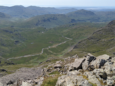 |
| The River Esk flowing south towards Hardknott |
 |
| Wast Water and the west coast from the South Peak |
16. To continue to Lingmell, retrace your steps to the main summit platform area and then head west, beyond the triangulation column. This time, don't turn down back towards Mickledore, but take the path heading north-west across the rocks towards Lingmell Col.
 |
| Head down to the col and then up the fell ahead of you |
17. The route is easy to follow. First make your way down towards the col along the well-worn tourist route. Then, as the main path sweeps left towards Hollow Stones, continue straight across the grassy col and up the clear path climbing the fellside ahead. This brings you to the summit of Lingmell (2649').
 |
| At the summit of Lingmell |
18. Lingmell is another peak where you can feel satisfied that, having stretched your legs only a short distance from the main crowds, you find yourself sharing a fantastic view with very few others! And, once again, a short walk beyond the highest point brings you to an even better view, this time from the top of Lingmell Crag, looking over to Great Gable. The viewpoint is marked by an elegant tall cairn.
 |
| Great Gable from the cairn on top of Lingmell Crag |
19. As you walk back towards Lingmell Col, look out for two other fine views. Firstly, the view towards Pillar and the Mosedale Horseshoe to the north-west, and secondly, as you descend back to Lingmell Col, the view down into the deep gully of Piers Gill.
 |
| Pillar and the Mosedale Horseshoe to the north-west |
 |
| Styhead Tarn and the deep gully of Piers Gill |
20. You may now have climbed both 'Wainwrights', but there's still plenty of interest left in this route. You now have a choice of two excellent return routes - either 'above Piers Gill' or the 'Corridor Route'. Either way, you first need to make your way to the head of Piers Gill by making your way east from Lingmell Col. Use the course of an old stone wall to guide you, with a visible path running roughly parallel with the wall, but a little above it, to its south. Don't try and cross the gill any further north, closer to Lingmell. As you will soon see, a precipitous drop will bar your way!
 |
| Head east above the old stone wall to the top of Piers Gill |
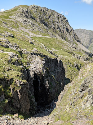
21. You will arrive at the head of Piers Gill. A small streambed (more usually containing a stream, depending on the season) deepens remarkably quickly to form a narrow ravine making a deep gash in the fellside beneath Lingmell. Cross the top of Piers Gill and then make your choice of route - either north-west, following the gill above its right bank, or, alternatively, continuing north-east on the 'Corridor Route' along the bottom of the ridge between Scafell Pike and Great End. 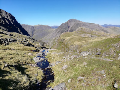 |
| One of the small streams that falls into Piers Gill |
 |
| Lingmell, as you cross Piers Gill |
Above Piers Gill
22A. Even the revised Wainwright Guide to the Southern Fells describes this route as being 'pathless' but its growing popularity means that there is now a fairly distinct path to follow, running safely ABOVE the eastern side of the gill. Do NOT attempt to descend into the ravine itself however!
 |
| Great Gable from the Piers Gill path |
23A. The gill, and the path above it, takes a sharp turn to the right underneath Lingmell Crag and then continues to descend, now in a north-easterly direction. The going is fairly, straightforward apart from one section where there is a short steeper descent over a stretch of rock. |
| Looking back up Piers Gill to Lingmell |
24A. Towards the bottom of the descent, the ravine opens out and the gill flows down a wider riverbed, forming beautiful waterfalls and pools. The path descends alongside it, through the bracken. It then joins the 'Valley Route' path heading down from Sty Head, shortly before crossing to the northern bank of the Lingmell Beck.
 |
| Time for a swim under Great Gable? |
25A. On a hot summer's day (they do come along every now and again!) the pools in the Lingmell Beck provide perfect spots for a cooling dip at the end of a long hike.
via the Corridor Route
22B. Continue on the clear path skirting around the bottom of Broad Crag. It passes above some small tarns below you, on your left.
 |
| Great Gable across a small tarn below the Corridor Route |
23B. Again, the route is fairly straightforward apart from one point where you have to clamber up over a short rocky section before continuing on the clear path.
 |
| Heading to Sty Head on the Corridor Route |
24B. The Corridor Route finishes when it meets the footpath that leads from Sty Head to Sprinkling Tarn. Turn left onto this path, down to the col at Sty Head. Then, rather than taking the direct path to Wasdale across the flank of Great Gable, a much better choice is to turn down into 'Spout Head', the head of the valley formed by the Spouthead Gill. In fact this can be reached directly by a short-cut downhill from the Corridor Route at the point where it crosses the Skew Gill.
 |
| The end of the Corridor Route, above Styhead Tarn |
25B. This 'Valley Route', rather indistinct at first, descends the valley on the southern side of the Spouthead Gill. Make your way down the grassy slopes before crossing back to the western, Great Gable, side of the gill near to where its waters meet those of Piers Gill, flowing down from under Lingmell. Shortly ahead, you will find the best stretch of the Lingmell Beck for finding a pool to swim in.
 |
| On the 'Valley Route' alongside Spouthead Gill |
26. Follow the now distinct path along the northern side of the beck. You will reach the walled areas where Herdwick sheep will be grazing. At a signposted junction, the path will be joined from the right by the direct path coming down from Sty Head, across the southern flank of Great Gable. Continue on the track, over a footbridge, and then make your back to Wasdale Head.
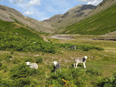 |
| Looking back up the valley between Great Gable and Lingmell |
Worth knowing: An alternative route to the summit of Scafell Pike goes via Esk Hause, a col reached either from Great Langdale or from routes ascending via Sty Head. A path climbs from the col, across the southern flank of Great End.
 |
| The path from Esk Hause (from the slopes of Great End) |
The route makes its way across the undulating ridge running from Great End to Scafell Pike, on a clear path but over scree and rocky terrain in some sections.
 |
On the ridge between Great End and Ill Crag
|
The path passes a little way to the right of the summit of Ill Crag (3068') and then, after dropping into the Ill Crag col, climbs uphill again to cross Broad Crag just to the left of its summit (3054'). These two subsidiary peaks of Scafell Pike are significant peaks in their own right but were not classified as separate summits by Wainwright when compiling his Walking Guides.
 |
| Heading up to Broad Crag with Scafell Pike in the distance |
 |
| Crossing the Broad Crag col with Piers Gill far below |
The path then drops again into the Broad Crag col before climbing up to the summit of Scafell Pike itself, arriving at the summit platform from the east.


